List of barrios and sectors of Yabucoa, Puerto Rico
Like all municipalities of Puerto Rico, Yabucoa is subdivided into administrative units called barrios, which are roughly comparable to minor civil divisions,[1] (and means wards or boroughs or neighborhoods in English). The barrios and subbarrios,[2] in turn, are further subdivided into smaller local populated place areas/units called sectores (sectors in English). The types of sectores may vary, from normally sector to urbanización to reparto to barriada to residencial, among others. Some sectors appear in two barrios.[3][4][5][6][7][8]

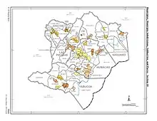
Yabucoa map with barrio subdivisions
List of sectors by barrio
Aguacate
- Camino Antonio Rodríguez
- Camino El Cabrito
- Camino Luis Ortiz
- Extensión Villas de Buenaventura
- Parcelas Comunas Nuevas
- Parcelas Comunas Viejas
- Sector Aguacate Adentro
- Sector Aguacate Arriba
- Sector Calle El Sol
- Sector El Cerro
- Sector Ingenio
- Sector Jagueyes
- Sector La Curva
- Sector Los Alicea
- Sector Mariana II
- Sector Parrilla
- Sector Raja Boca
- Urbanización Alturas de Terralinda
- Urbanización Villas de Buenaventura
Calabazas
- Carretera 900
- Parcelas Nuevas
- Sector Calabazas Arriba
- Sector Guayabo
- Sector Playita Arriba
- Sector Playita
- Sector Rincón
- Sector Sodoma o Calabazas Adentro
- Sector Vieques
- Sector Villa Kilí
- Sector y Parcelas Rosa Sánchez
- Urbanización Jaime C. Rodríguez
- Urbanización Santa María
- Urbanización Valles de las Calabazas
Camino Nuevo

US 2010 Census map of subdivisions of Yabucoa and its neighboring municipios to the north
- Carretera 901
- Parcelas Camino Nuevo
- Sector El Cocal
- Sector El Guano
- Sector El Negro
- Sector El Nuevo Cuño
- Sector Loma del Viento
- Sector Los Colones
- Sector Maloja
- Sector Riefkohl
- Sector Rincón
- Sector Tamarindo
Guayabota
- Camino Doña Zaza
- Sector El Cruce
- Sector El Veinte
- Sector La Aldea
- Sector La Coa
- Sector La Herradura
- Sector Las Panas
- Sector Los Sánchez
- Sector Quebrada Grande
- Sector Quebradillas
- Sector Surillo
- Sector Tres Puntos
Jácanas
- Sector Campo Alegre
- Sector Jácanas Abajo
- Sector Jácanas Arriba
- Sector Jácanas Granja
- Sector Jácanas Sur
- Sector Piedras Blancas
Juan Martín
- Apartamentos Ernesto Carrasquillo
- Barriada Poblado Varsovia
- Residencial Dr. Víctor Berríos
- Reparto Horizonte
- Sector Central Roig
- Sector Cerro Santa Elena
- Sector La Pica
- Sector La Villa
- Sector Las Panas
- Sector Los Casanova
- Sector Pandura
- Urbanización Méndez
- Urbanización Santa Elena
- Urbanización Solimar
- Urbanización Valles de Yabucoa
- Urbanización Villa Hilda
Limones
- Parcelas Martorell
- Sector Borinquen
- Sector La Casa
- Sector La Laura
- Sector Martorell Arriba
- Sector Vieques
Playa

Urbanización Vista Mar in Playa barrio in Yabucoa
- Sector Calambreñas
- Sector El Hoyo
- Sector Gandular
- Sector Las Lomas
- Sector Los Pavos
- Sector Los Pinos
- Sector Paraíso I
- Sector Paraíso II
- Sector Parrilla
- Sector Playa Guayanés[9]
- Sector Veteranos
- Sector Windy Hills
- Urbanización Vista Mar
Tejas
- Carretera 639
- Sector Los Tres Puntos
- Sector Piedra Azul
- Sector Tejas Afuera y Adentro
- Sector Valerio Velázquez
Yabucoa barrio-pueblo
- Sector El Tosquero
- Sector Poblado Calvario
- Urbanización Francisco Sustache
- Urbanización Jardines de Yabucoa
- Urbanización Los Angeles
- Urbanización Nueva
- Urbanización Ramos Antonini
- Urbanización Villa Recreo
- Urbanización Yabucoa Real
See also
References
- "US Census Barrio-Pueblo definition". factfinder.com. US Census. Archived from the original on 13 May 2017. Retrieved 5 January 2019.
- "P.L. 94-171 VTD/SLD Reference Map (2010 Census): Yabucoa Municipio, PR" (PDF). www2.census.gov. U.S. DEPARTMENT OF COMMERCE Economics and Statistics Administration U.S. Census Bureau. Archived (PDF) from the original on 22 August 2020. Retrieved 22 August 2020.
- "PRECINTO ELECTORAL YABUCOA 093" (PDF). Comisión Estatal de Elecciones (in Spanish). PR Government. 26 July 2020. Archived (PDF) from the original on 4 January 2021. Retrieved 4 January 2021.
- Mari Mut, José A. (28 August 2013). "Los pueblos de Puerto Rico y las iglesias de sus plazas" (in Spanish). Retrieved 19 June 2020 – via archive.org.
- "Agencia: Oficina del Coordinador General para el Financiamiento Socioeconómico y la Autogestión (Proposed 2016 Budget)". Puerto Rico Budgets (in Spanish). Archived from the original on 28 June 2019. Retrieved 28 June 2019.
- Rivera Quintero, Marcia (2014), El vuelo de la esperanza : Proyecto de las Comunidades Especiales Puerto Rico, 1997-2004 (Primera edición ed.), San Juan, Puerto Rico Fundación Sila M. Calderón, ISBN 978-0-9820806-1-0
- "Leyes del 2001". Lex Juris Puerto Rico (in Spanish). Archived from the original on 14 September 2018. Retrieved 24 June 2019.
- "Comunidades Especiales de Puerto Rico" (in Spanish). 8 August 2011. Archived from the original on 24 June 2019. Retrieved 24 June 2019.
- "Inauguran muelle de Villa Pesquera en Playa Guayanés". Victoria840 (in Spanish). 2019-04-13. Retrieved 2020-11-01.
This article is issued from Wikipedia. The text is licensed under Creative Commons - Attribution - Sharealike. Additional terms may apply for the media files.