Lawford
Lawford is a large village and civil parish in the Tendring district of northeast Essex, England. It is approximately 6 miles (10 km) northeast from the centre of Colchester and west of, and contiguous with, Manningtree. Mistley merges with the east side of Manningtree.
| Lawford | |
|---|---|
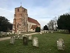
 St Mary's Church, Lawford | |
 Lawford Location within Essex | |
| Population | 4,302 (2011)[1] |
| OS grid reference | TM092310 |
| • London | 55 mi (89 km) SW |
| District | |
| Shire county | |
| Region | |
| Country | England |
| Sovereign state | United Kingdom |
| Post town | Manningtree |
| Postcode district | CO11 |
| Dialling code | 01206 |
| Police | Essex |
| Fire | Essex |
| Ambulance | East of England |
| UK Parliament | |
The Leftley Housing estate, situated towards the east of the village, is a typical 1960s development of mainly semi-detached houses and bungalows.
The area includes a number of smallholdings originally built by the Land Settlement Association.[2]
The 14th-century parish Church of St Mary is a Grade I listed building.[3]
References
- "Civil Parish population 2011". Neighbourhood Statistics. Office for National Statistics. Retrieved 4 September 2016.
- Bercaw, Louise Oldham; "Bibliography on Land Utilization 1918-36"; p. 1011
- Historic England. "Church of St Mary (1261462)". National Heritage List for England. Retrieved 22 April 2014.
External links
 Media related to Lawford at Wikimedia Commons
- Lawford Parish Council
- Manningtree High School
This article is issued from Wikipedia. The text is licensed under Creative Commons - Attribution - Sharealike. Additional terms may apply for the media files.