Langley Covered Bridge
Langley Covered Bridge is the longest remaining wooden covered bridge in the U.S. state of Michigan, and is located three miles north of Centreville, the seat of St. Joseph County. The bridge is located in Lockport Township. The road to get to the bridge borders on the east line of Lockport and Nottawa townships. The bridge crosses the St. Joseph River. The current bridge and causeway opened in 1887. The bridge and causeway make up Covered Bridge Road.
Langley Covered Bridge | |
|---|---|
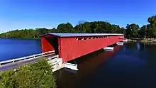
 Langley Covered Bridge—September 2016 | |
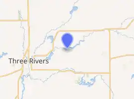
| Coordinates | 41°58′02″N 085°31′41″W |
| Carries | Covered Bridge Road |
| Crosses | St. Joseph River |
| Locale | Centreville, Michigan |
| Maintained by | St. Joseph County Road Commission |
| Characteristics | |
| Design | Howe truss |
| Total length | 282 ft (86 m)[1] |
| No. of spans | 3 |
| Load limit | 3 short tons (2.7 t) |
| Clearance above | 7 ft (2.1 m) |
| History | |
| Construction end | 1887[2] |
| Designated | August 31, 1965 |
| Location | |

| |
History
The bridge is not the first bridge to span this section of the St. Joseph River. In 1887 a swollen St. Joseph River swept away that bridge that was about two blocks from the current bridge location.[3] The current bridge was constructed in 1887 by nearby Parkville builder Pierce Bodmer.[4] Both Lockport and Nottawa Township commissioned the bridge which cost about $3,000.[3] The bridge is named for Thomas W. Langley and family, pioneers who helped establish the village of Centreville in the mid-19th century.[5] In fact, Langley was the very first settler in Centreville.[6]
Restoration work
In the 1940s, as motor vehicle traffic started to replace the horse and buggy and foot traffic, the added weight and vibration started to cause damage to the bridge and abutments and required repair.[3] "The road commission was flooded with requests from all parts of the state and surrounding states to do everything possible to keep the covered bridge intact." [3] The Elkhart Bridge and Iron Works was awarded the contract to fix the bridge. The 1950-51 project was to give the bridge a new under structure at a cost of $35,885.[7] In September 1950 the bridge was closed to traffic so work could begin and did not reopen till August 1951.[7] During the closure "All the load carrying elements of the bridge were changed from wood to steel or concrete. The old flooring was replaced with two by fours creosoted."[7]
When the bridge was again in need of major repair, the St. Joseph County Road Commission hired Anlaan Corporation to perform the restoration work. All of the siding was removed from the bridge and the roof was replaced. The asphalt that had been added to road decking was removed and returned to wood planking. The cost of the 2008-09 repair was almost $1 million. During this Restoration project two Height Restrictor portal frames and signs were added.
Replacement
In 1964 the bridge became the center of controversy when the then county road official wanted to widen the road between Centreville and Vicksburg.[8]
Tourism
Many of the covered bridges in Michigan and other states no longer exist, and therefore the structure is a historic[4] For almost 130 years the covered bridge has been a scenic point for travelers, artist photographers hoping to capture the changing shadows of the bridge.[3] The bridge draws history and bridge buffs see the longest covered bridge in Michigan.[3] Another reason people come to the bridge is to fish from inside the bridge.[3]
Facts and figures
The bridge spans 282 feet (86 m) across the river, it is made up of three spans and is made of the Howe truss construction. Its frame and timbers are constructed of White pine. The original bridge section are made from three 94-foot (29 m) sections which are joined together to form the 282-foot (86 m) length of the bridge. They measure 19 feet (5.8 m) wide by 16 feet (4.9 m) high. The original bridge's planking and decking rests on 40 beams that measure 8 inches (20 cm) by 12 inches (30 cm) by 19 feet (5.8 m) long.[3] It is estimated on average that 1,700 vehicles a day use the bridge. During the 2008–09 project on the bridge, two Heigh restrictor portal frames and signs were add at the cost of $20,000 each for a total $40,000 to help protect the bridge.[9]
When the Sturgis Dam was installed the bridge had to be raised eight feet (two point four metres). In a two-year period, 1950–51, the St. Joseph County Road commission undertook work to help preserve the bridge for use by future generations. To accomplish this the old foundation timbers had to be replaced by wood reinforced with steel beams. The cost of the repair was almost $36,000 (equivalent to $288000 in 2019[10]).
There are three main restrictions on the bridge. There is a three-short-ton (two-point-seven-tonne) weight limitation, a seven-foot (2.1 m) height restriction, and there is a limit on how wide vehicles can be.[5] There are many warning signs leading up to the bridge to warn of the restrictions. The Saint Joseph County Road Commission has attempted some creative ways to stop people from damaging the bridge. Despite the signs, people have hit the metal sign and damaged it beyond repair in 2016. The sign was replaced.[11]
Other events
The bridge has been a very important symbol for the village of Centreville for almost 100 years. Since 1975 the village's annual summer festival is called Covered Bridge Days. A local newspaper that operated in 1960 used the sketch of the bridge as its logo at different times.[12]
The Three Rivers Chamber of Commerce hosted what was billed a once-in-a-lifetime event, where the bridge was closed to host a charity dinner. The event was done in coordination with the county road commission that had some planned deck work on the bridge.[13]
Photo gallery
 Aerial photo taken from drone
 Aerial photo taken from drone of sign protecting bridge from oversize vehicles
 A picture showing the inside of the covered bridge from an angle to show decking and road bed
 A view of the Howe Truss System spanning the 282 feet (86 m) of the bridge
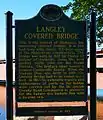
 A photo of the Michigan Historical Marker placed on the bridge
See also
 Transport portal
 Engineering portal
 Michigan portal
References
- "Langley Bridge (1887)". Structurae (in German). Retrieved May 23, 2012.
- AdminBSnook (November 11, 2009). "Langley Covered Bridge Opens to Traffic". River Country Journal. Archived from the original on February 18, 2013. Retrieved April 15, 2012.
- Jessup, Kathy (September 25, 2011). "From Surreys to SUVs: Historic Langley Covered Bridge Still Accommodates Vehicles One at a Time". MLive. Booth Newspapers. Retrieved September 27, 2016.
- Michigan State Historic Preservation Office (n.d.). "Langley Covered Bridge". Michigan State Housing Development Authority. Archived from the original on February 19, 2012. Retrieved May 23, 2012.
- Craig, Kevin (April 14, 2015). "Michigan's Longest Covered Bridge is in Centreville". Fox 17 Online. Grand Rapids, MI: WXMI-TV. Retrieved September 27, 2016.
- "10 Great Places to Cross that Covered Bridge". USA Today. June 12, 2006. Retrieved May 23, 2012.
- "Salt and Pepper". The Centreville Observer. November 1, 1951. p. 2.
- "Rustic Landmark Will Stay Untouched for Another Year". The News-Palladium. Benton Harbor, MI. February 10, 1964. p. 1.
- State of Michigan. TMS-Port Database Summary of Project for Contract 78061-83650 (Report). State of Michigan.
- Thomas, Ryland; Williamson, Samuel H. (2020). "What Was the U.S. GDP Then?". MeasuringWorth. Retrieved September 22, 2020. United States Gross Domestic Product deflator figures follow the Measuring Worth series.
- Rietsma, Jef (July 28, 2016). "Covered bridge sign damaged in separate incidents". Strugis Journal. Retrieved September 27, 2016.
- Grossman, Al (May 28, 1969). "The St. Joseph County Observer". The St. Joseph County Observer. Centreville, MI.
- Rietsma, Jeff (July 30, 2013). "Historic Covered Bridge in St. Joseph County to Be Site for Unique Fundraiser". MLive. Booth Newspapers. Retrieved September 27, 2016.
External links
 Media related to Langley Covered Bridge at Wikimedia Commons