La Dauversière Lake
The La Dauversière Lake is a freshwater body integrated into a set of lakes designated "Obatogamau Lakes, in the territory of Eeyou Istchee James Bay (municipality), in the administrative region of Nord-du-Québec, province of Quebec, in Canada. This lake extends entirely in the township of La Dauversière.
| La Dauversière Lake | |
|---|---|
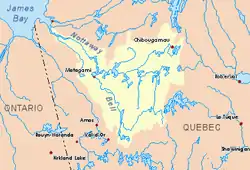
 Watershed of Nottaway River | |
 La Dauversière Lake | |
| Location | Eeyou Istchee Baie-James |
| Coordinates | 49°34′00″N 74°22′10″W |
| Type | Natural |
| Primary inflows |
|
| Primary outflows |
|
| Basin countries | Canada |
| Max. length | 10.6 kilometres (6.6 mi) |
| Max. width | 9.9 kilometres (6.2 mi) |
| Surface elevation | 365 kilometres (227 mi) |
Forestry is the main economic activity of the sector. Recreational tourism activities come second.
The hydrographic slope of Lac La Dauversière is accessible by a branch of a road to the north at route 113 (linking Lebel-sur-Quevillon and Chibougamau) and the Canadian National Railway.
The surface of Lac La Dauversière is usually frozen from early November to mid-May, but it is safe from mid-November to mid-April.
Geography
As part of the Lake Obatogamau reservoir, Lac La Dauversière has a length of 10.6 kilometres (6.6 mi), a maximum width of 9.9 kilometres (6.2 mi) and an altitude of 365 metres (1,198 ft).
The lake La Dauversière has a rather complex shape with several bays, peninsulas and islands. The main islands are: Weaver, Birch, Americans and Ducks. The main points are: Nipples and Cemetery. The main bays are: Three Lakes Bay, Nemenjiche Bay, First Bay of Obatogamau Lakes, Second Bay of Lakes Obatogamau and Third Bay of Obatogamau Lakes.
Lac La Dauversière gets its supplies from the North-East side of the mill and Calmor lakes; on the east side by Audet Creek; on the southeast side, by Royer Lake outlet; on Obatogamau lakes. The Obatogamau River (tributary of the Chibougamau River) drains this large body of water. The mouth of Lake Dauversière is located at the bottom of a bay in the Southwest at:
- 24.9 kilometres (15.5 mi) east of the mouth of the Eau Jaune Lake;
- 35.2 kilometres (21.9 mi) east of the mouth of the Presqu'île Lake (Nord-du-Québec);
- 83.2 kilometres (51.7 mi) east of the mouth of the Obatogamau River (confluence with the Chibougamau River);
- 113.2 kilometres (70.3 mi) north-east of the mouth of the Chibougamau River (confluence with the Opawica River);
- 35.1 kilometres (21.8 mi) south of downtown Chibougamau;
- 37.4 kilometres (23.2 mi) south-east of the village center of Chapais.[1]
The main hydrographic slopes near La Dauversière Lake are:
- North side: Merrill Lake, Dorés Lake (Chibougamau River), Chibougamau Lake, Chibougamau River;
- East side: Boisvert River (Normandin River), Boisvert Lake;
- South side: Le Royer Lake, Opawica River, Nemenjiche River;
- West side: Eau Jaune Lake, Muscocho Lake, Irene River, Obatogamau River.
Lac La Dauversière empties on the west side by a short strait in Le Royer Lake.
Toponymy
In 1910, the Hudson's Bay Company built on the eastern shore of "lac La Dauversière" a cabin which will become over the years a place of storage. Finally this cabin was deserted. Originally known as "Dépôt-du-Lac-La Dauversière". In 1988, this place name will be standardized in the form of "Dépôt-des-Lacs-La Dauversière", as a locality.[2]
The toponym "Lac La Dauversière" was made official on December 5, 1968 by the Commission de toponymie du Québec, when it was created.[3]
Notes and references
- Distances from the Atlas of Canada (published on the Internet) by the Department of Natural Resources Canada.
- Source: Names and places of Quebec, work of the "Commission de toponymie du Québec" published in 1994 and 1996 in the form of a printed illustrated dictionary, and in the form of a CD-ROM produced by the company Micro-Intel, in 1997, from this dictionary.
- Commission de toponymie du Québec - Bank of Place Names - Toponym: "Lac La Dauversière"
See also
- Nottaway River, a watercourse
- Matagami Lake, a body of water
- Waswanipi River, a watercourse
- Chibougamau River, a watercourse
- Obatogamau River, a watercourse
- Obatogamau Lakes, a set of bodies of water
- Eeyou Istchee Baie-James (municipality), a municipality
- List of lakes in Canada