Krylov Seamount
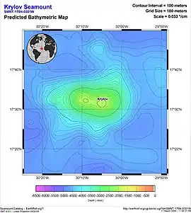
Krylov Seamount (also known as Albatross Seamount[2] or Krylou Seamount[3]) is a volcanic seamount in the Atlantic Ocean, west of the Cape Verde islands. It is formed by one seamount and one ridge which are separated by a 5 kilometres (3.1 mi) wide depression, and it rises to a minimum depth of 1,240 metres (4,070 ft); formerly the depression was interpreted to be a caldera. The seamount probably formed no later than 70-75 million years ago before sinking to its current depth.
| Krylov Seamount | |
|---|---|
 Krylov Seamount Krylov Seamount (North Atlantic) | |
 | |
| Summit depth | 1,240 metres (4,070 ft) |
| Location | |
| Coordinates | 17°31′N 30°07.5′W[1] |
History and name
The seamount was discovered in 1981 by a Russian research ship and named after the Russian researcher Aleksey Krylov.[2]
Geography and geomorphology
Krylov Seamount lies 300 kilometres (190 mi)[1] west of the Cape Verde islands[4] in the Cape Verde Basin[5] of the East Atlantic,[6] at a water depth of 4,600–4,700 metres (15,100–15,400 ft); the highest point lies at 1,270 metres (4,170 ft)[7] and the seamount rises about 3,200 metres (10,500 ft) above the seafloor.[8] It is an elongated volcano that consists of an eastern summit at about 1,240 metres (4,070 ft) depth ("Krylov Seamount" proper), separated from a 15–20 kilometres (9.3–12.4 mi) western ridge ("Krylov Ridge") by a 5 kilometres (3.1 mi) wide depression.[9] Formerly, the whole seamount was interpreted to be an apparently volcanic breccia-filled[1] summit caldera[7] plus three separate summits sharing a common pedestal at 2,500–2,600 metres (8,200–8,500 ft) depth. The terrain of the seamount is covered by organic debris, which with depth gives way to pillow lavas;[10] marine sediments cover much of the outer slopes of the seamount.[1] The seafloor under Krylov is about 95 million years old.[11]
Geology and geochronology
The seamount was probably formed by a mantle diapir[7] with eruptions occurring along fissures and in association with the Mid-Atlantic Ridge. It probably began to form no less than 70-75 million years ago, as reefs of that age containing coccoliths, corals and foraminifers have been found on the seamount; they also indicate that the seamount was emergent at that time. The seamount may have risen between 1,100–2,000 metres (3,600–6,600 ft) above sea level before thermal subsidence lowered it to its current depth.[12][10] Corals, golden corals, sea stars and sponges have been found at Krylov Seamount.[13]
Composition
Compositionally, the seamount is formed by alkali basalts and hydrothermally altered basalts[7] containing palagonite and plagioclase[14] with additional clay, hyaloclastite and palygorskite;[15] additionally it features biogenic limestone, carbonate sands,[7] carbonate sandstone, corals, foraminifera sands,[16] iron-manganese crusts, muddy sands, sands, shelly debris and volcanic breccia.[7] The volcanic rocks display some geochemical differences between the western ridge and the eastern summit.[9]
These iron-manganese crusts can be as much as 10 centimetres (3.9 in) thick.[17] Vernadite is among the most important components of the iron-manganese crusts, followed by manganese-containing feroxyhyte;[15] additional components are apatite,[18] asbolane, birnessite, buserite,[19] goethite, mica smectite, smectite, palygorskite, quartz,[20] todorokite[19] and zeolites.[20] The formation of the iron-manganese crusts was influenced by hydrothermal activity, when Krylov Seamount was close to the Mid-Atlantic Ridge about 97 million years ago (Cenomanian).[18]
References
- Duggen 2009, p. 9.
- "Marine Regions · Krylov Seamount (Seamount(s))". www.marineregions.org. Flanders Marine Institute. Retrieved 6 May 2019.
- "Sixth Meeting of the GEBCO Sub-Committee on Geographical Names and Nomenclature of Ocean Bottom Features" (PDF). International Hydrographic Organization. April 1985. p. 7. Retrieved 6 May 2019.
- Il'in 2000, p. 857.
- Varentsov et al. 1991, p. 53.
- Il'in 2000, p. 856.
- Varentsov et al. 1991, p. 54.
- Litvin, V. M. (2013). The Morphostructure of the Atlantic Ocean Floor: Its Development in the Meso-Cenozoic. Springer Science & Business Media. p. 36. ISBN 9789400962453.
- Duggen 2009, p. 10.
- Il'in 2000, p. 866.
- Long et al. 2020, p. 391.
- Long et al. 2020, p. 395.
- Duggen 2009, p. 41,57.
- Duggen 2009, p. 39.
- Varentsov et al. 1991, p. 55.
- Duggen 2009, p. 15.
- Koschinsky, Andrea; Gerven, Marc Van; Halbach, Peter (1 January 1995). "First investigations of massive ferromanganese crusts in the NE Atlantic in comparison with hydrogenetic pacific occurrences". Marine Georesources & Geotechnology. 13 (4): 376. doi:10.1080/10641199509388294. ISSN 1064-119X.
- Varentsov et al. 1991, p. 67.
- Varentsov et al. 1991, p. 58.
- Varentsov et al. 1991, p. 56.
Sources
- Duggen, Svend (2009). "FS POSEIDON Fahrtbericht / Cruise Report P379/1: Vulkanismus im Karibik-Kanaren-Korridor (ViKKi), Las Palmas - Mindelo, 25.01.-12.02.2009 (POS379/1)". Kiel. doi:10.3289/ifm-geomar_rep_28_2009. Cite journal requires
|journal=(help)CS1 maint: ref=harv (link) - Il'in, A. V. (2000). "On the Origin and Evolution of the Atlantis, Cruiser, Meteor, Rocket, and Krylov Seamounts in the Atlantic Ocean". Oceanology. 40: 856–867. ISSN 0001-4370.CS1 maint: ref=harv (link)
- Long, Xiaojun; Geldmacher, Jörg; Hoernle, Kaj; Hauff, Folkmar; Wartho, Jo‐Anne; Garbe‐Schönberg, C.‐Dieter (October 2020). "Origin of isolated seamounts in the Canary Basin (East Atlantic): The role of plume material in the origin of seamounts not associated with hotspot tracks". Terra Nova. 32 (5): 390–398. doi:10.1111/ter.12468.
- Varentsov, I.M.; Drits, V.A.; Gorshkov, A.I.; Sivtsov, A.V.; Sakharov, B.A. (January 1991). "Mn-Fe oxyhydroxide crusts from Krylov Seamount (Eastern Atlantic): Mineralogy, geochemistry and genesis". Marine Geology. 96 (1–2): 53–70. Bibcode:1991MGeol..96...53V. doi:10.1016/0025-3227(91)90201-E.CS1 maint: ref=harv (link)