Krathum Baen District
Krathum Baen (Thai: กระทุ่มแบน, pronounced [krā.tʰûm bɛ̄ːn]) is a district (amphoe) in the northern part of Samut Sakhon Province, central Thailand.
Krathum Baen
กระทุ่มแบน | |
|---|---|
 District location in Samut Sakhon Province | |
| Coordinates: 13°39′21″N 100°16′4″E | |
| Country | Thailand |
| Province | Samut Sakhon |
| Area | |
| • Total | 135.276 km2 (52.230 sq mi) |
| Population (2017) | |
| • Total | 175,983 |
| • Density | 1,300.91/km2 (3,369.3/sq mi) |
| Time zone | UTC+7 (ICT) |
| Postal code | 74110, 74130 |
| Geocode | 7402 |
History
Krathum Baen was a part of Mueang Samut Sakhon District. It was created in 1900. In 1926 the government added Tambons Tha Mai, Bang Yang, Nong Kok Khai, and Om Noi of Sam Phran District, Nakhon Pathom Province to the district.
Geography
Neighbouring districts are (from the north clockwise): Sam Phran of Nakhon Pathom Province; Nong Khaem and Bang Bon of Bangkok; Mueang Samut Sakhon and Ban Phaeo of Samut Sakhon Province.
The important water resources are the Tha Chin river and Phasi Charoen canal.
The name Krathum Baen meaning 'flat burflower-tree'.
Administration
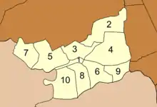
The district is divided into 10 subdistricts (tambons), which are further subdivided into 76 villages (mubans). There is a city (thesaban nakhon), Om Noi, and a town (thesaban mueang), Krathum Baen. The non-municipal area is administered by eight tambon administrative organizations (TAO).
|
 Map of subdistricts |