Kilmore, County Down
Kilmore is a village, civil parish and townland of 149 acres (60 ha) in County Down, Northern Ireland, about 1 mile (1.6 km) from Crossgar. It is situated in the historic baronies of Castlereagh Upper and Kinelarty.[1]
Kilmore
| |
|---|---|
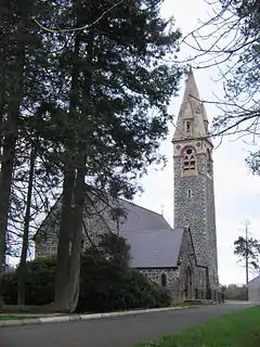
 Christ Church, Parish of Kilmore | |
 Location within County Down | |
| Population | 500 (2011 Census) |
| District | |
| County | |
| Country | Northern Ireland |
| Sovereign state | United Kingdom |
| Post town | DOWNPATRICK |
| Postcode district | BT30 |
| Dialling code | 028 |
| Police | Northern Ireland |
| Fire | Northern Ireland |
| Ambulance | Northern Ireland |
| UK Parliament | |
| NI Assembly | |
History
Kilmore derives its name from the Irish word 'an Chill Mhór', meaning "the big church",[2] as it is most famous for the historic 18th century Anglican church the building for which is now located in the Ulster Folk and Transport Museum. Eighty years after the church was built in 1790, a new church was built nearby in 1870 to heal rifts within the church concerning the nature of Anglo-Catholic worship in the decades prior. It remains the place of worship for the same Church of Ireland congregation Church Parish of Kilmore to this day.[3]
Sport
Kilmore has a Football Club called Kilmore Rec FC, which plays at Robert Adams Park, Crossgar.
Civil parish of Kilmore
The civil parish contains the villages of Crossgar and Kilmore.[1]
Townlands
The civil parish contains the following townlands:[1]
- Ballydyan
- Barnamaghery
- Broaghclogh (also known as Murvaclogher)
- Cahard
- Carnacally
- Clontaghnaglar
- Creevyargon
- Creevycarnonan
- Crossgar
- Drumaghlis
- Drumgiven
- Drumnaconagher
- Kilmore
- Lisnamore
- Lissara
- Listooder
- Magheralone
- Murvaclogher (also known as Broaghclogh)
- Rademon
- Raleagh
- Rossconor
- Teconnaught
- Tullynacree
References
- "Kilmore". IreAtlas Townlands Database. Retrieved 17 May 2015.
- "Placenames Database of Ireland". Logainm.ie.
- Northern Ireland, National Museums. "Kilmore Parish Church". Retrieved 9 February 2014.