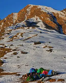
Khaliya Bugyal
"Khaliya Bugyal" is a Bugyal (Himalayan Alpine Meadow) in the Pithoragarh district of Uttarakhand. Khaliya Bugyal is a popular Trekking and Skiing Destination. The Bugyal has the highest elevation of 3709m and is around 16 km from Munsiyari. Khaliya Bugyal is situated between the snowy peaks and the forests of Deodar, Pine and Rhododendrons.[1]
| Khaliya Bugyal | |
|---|---|
 Khaliya Bugyal | |
| Highest point | |
| Elevation | 3,709 m (12,169 ft) |
| Coordinates | 30.0639105°N 80.1880322°E |
| Geography | |
| Location | Pithoragarh district, Uttarakhand, India |
| Parent range | Garhwal Himalaya |
The best time to visit the Khaliya Bugyal is either in the Spring or the Winters. In springs, there is Greenery of the grasslands and red and pink rhododendron.The Khaliya Bugyal is a paradise for nature photographers and bird watchers.[2] In winters, the bugyal turns into snow land and skiing activities take place at Khaliya Bugyal organised by Uttarakhand Tourism Development Board. The Trek to Khaliya Bugyal starts from Munsiyari and is a 5-6 km trek from its starting point. One can see views of Garhwal Himalayas including Nanda Kot and Panchachuli peaks from Khaliya Bugyal.[3]
References
- "Khaliya Top". euttaranchal.com.
- "Khaliya Top". insider.in.
- "Khaliya Top". tripadvisor.com.