Kentucky Route 88
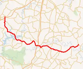
Kentucky Route 88 (KY 88) is a 56.604-mile-long (91.095 km) state highway in west central Kentucky. It traverses Grayson, Hart, and Green counties in Kentucky. It originates in Clarkson and ends near Greensburg
| ||||
|---|---|---|---|---|

KY 88 highlighted in red | ||||
| Route information | ||||
| Maintained by KYTC | ||||
| Length | 56.604 mi[1] (91.095 km) | |||
| Major junctions | ||||
| West end | ||||
| East end | ||||
| Location | ||||
| Counties | Grayson, Hart, Green | |||
| Highway system | ||||
| ||||
Route description
KY 88 begins in Clarkson, along US 62 in Grayson County. KY 88 traverses the Western Kentucky Parkway via an overpass without access. It passes through the community of Grayson Springs and Peonia and Wax. It enters Hart County crossing over the Nolin Lake. KY 88 then traverses Cub Run at the junction with KY 728 before going on to Munfordville. It runs concurrently with US 31W in downtown Munfordville over the Green River.
KY 88 splits from US 31W near the Hart County High School to continue east to cross US 31E at Hardyville. KY 88 enters Green County after passing through Monroe. It crosses the Green River a second time before ending near Greensburg along KY 61.
Major intersections
| County | Location | mi[1] | km | Destinations | Notes |
|---|---|---|---|---|---|
| Grayson | Clarkson | 0.000 | 0.000 | Western terminus | |
| 0.808– 0.87 | 1.300– 1.40 | Bridge over Access is denied | |||
| Grayson Springs | 2.426 | 3.904 | |||
| 2.536 | 4.081 | ||||
| Peonia | 5.962 | 9.595 | Eastern terminus of KY 226 | ||
| Iberia | 8.925 | 14.363 | Northern terminus of KY 889 (dead end road) | ||
| 11.046– 11.184 | 17.777– 17.999 | Bridge over Rock Creek Embayment of Nolin Lake | |||
| | 11.672 | 18.784 | Western terminus of KY 1356 | ||
| Wax | 13.555 | 21.815 | Southern terminus of KY 479 | ||
| Nolin Lake | 14.47– 14.538 | 23.29– 23.397 | Bridge over Nolin Lake Grayson--Hart County line | ||
| Hart | | 15.631 | 25.156 | Northern terminus of KY 1015 | |
| Cub Run | 19.661 | 31.641 | |||
| Kessinger | 26.717 | 42.997 | Eastern terminus of KY 2786 | ||
| Munfordville | 31.057– 31.109 | 49.981– 50.065 | Bridge over | ||
| Munfordville | 32.345 | 52.054 | Western end of US 31W overlap | ||
| 32.413 | 52.164 | Southern terminus of KY 357 | |||
| 32.939– 33.217 | 53.010– 53.458 | Bridge over Green River | |||
| 33.727 | 54.278 | Eastern end of US 31W overlap1 | |||
| | 36.953 | 59.470 | Western terminus of KY 1854 | ||
| Hardyville | 39.818 | 64.081 | |||
| 40.11 | 64.55 | Northern terminus of KY 570 | |||
| Monroe | 44.806 | 72.108 | Eastern terminus of KY 436 | ||
| 45.372 | 73.019 | ||||
| Green | | 51.99 | 83.67 | Southern terminus of KY 2765 | |
| | 52.786 | 84.951 | Northern terminus of KY 1464 | ||
| 53.065– 53.163 | 85.400– 85.558 | KY 88 Bridge over Green River | |||
| Greensburg | 56.604 | 91.095 | Eastern terminus | ||
1.000 mi = 1.609 km; 1.000 km = 0.621 mi
| |||||
References
- Commonwealth of Kentucky. "Official DMI Route Log". Retrieved February 28, 2017.
