K-239 (Kansas highway)
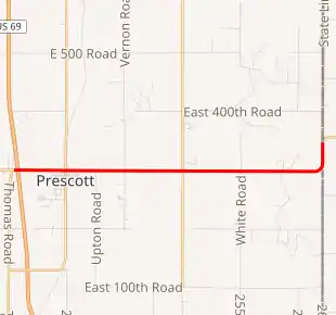
K-239 is a 5.677-mile-long (9.136 km) east–west state highway in the U.S. state of Kansas. K-239's western terminus is at U.S. Route 69 (US-69) west of the City of Prescott, and the eastern terminus is a continuation as Route A at the Missouri state line.[3] When K-239 was first designated it was a spur between US-69 and Prescott but was later extended east to the Missouri border.[2]
| ||||
|---|---|---|---|---|

K-239 highlighted in red | ||||
| Route information | ||||
| Maintained by KDOT | ||||
| Length | 5.677 mi[1] (9.136 km) | |||
| Existed | July 11, 1962[2]–present | |||
| Major junctions | ||||
| West end | ||||
| East end | ||||
| Location | ||||
| Counties | Linn | |||
| Highway system | ||||
| ||||
Route description
K-239 begins at an intersection with US-69 and travels east for 0.5 miles (0.80 km) and enters Prescott. It travels roughly 0.5 miles (0.80 km) through Prescott. After exiting Prescott it travels roughly 0.6 miles (0.97 km) and crosses Indian Creek. From here it continues east for approximately 3.4 miles (5.5 km) then curves north. At this point it begins paralleling the Missouri border for 0.5 miles (0.80 km) then curves east and crosses into Missouri becoming Missouri Route A.[3]
The Kansas Department of Transportation (KDOT) tracks the traffic levels on its highways, and in 2017, they determined that on average the traffic varied from 480 vehicles per day near the Missouri border to 1410 vehicles per day near the western terminus. The second highest was 1110 vehicles per day slightly east of Prescott.[4] K-239 is not included in the National Highway System.[5] The National Highway System is a system of highways important to the nation's defense, economy, and mobility. K-239 does connect to the National Highway System at its western terminus at US-69.[6] The first 0.834 miles (1.342 km) is paved with full design bituminous pavement and the remaining part of the route is paved with partial design bituminous pavement.[1][7]
History
Originally US-69 travelled directly north–south through Prescott. Then in a July 11, 1962 resolution, US-69 was moved onto a new alignment west of the city. At this time K-239 was created as a spur connecting Prescott to the new US-69.[2] Then in a January 8, 1964 resolution, K-239 was extended 4.843 miles (7.794 km) eastward to the Missouri State line to connect to Missouri Route A.[8]
Major intersections
The entire route is in Sheridan Township, Linn County.
| mi[1] | km | Destinations | Notes | ||
|---|---|---|---|---|---|
| 0.000 | 0.000 | Western terminus; diamond interchange | |||
| 5.677 | 9.136 | Continuation at Missouri state line | |||
| 1.000 mi = 1.609 km; 1.000 km = 0.621 mi | |||||
References
- Staff (2016). "Pavement Management Information System". Kansas Department of Transportation. Retrieved April 16, 2017.
- State Highway Commission of Kansas (July 11, 1962). "Resolution for Relocation and Redesignation of Road in Linn County". Topeka: State Highway Commission of Kansas. Retrieved August 29, 2019.
- KDOT (2010). 2010 Linn County Map (PDF) (Map). Scale not given. Topeka: KDOT. Retrieved August 29, 2019.
- Bureau of Transportation Planning (2018). Traffic Flow Map Kansas State Highway System (PDF) (Map). [c. 1:1,584,000]. Topeka: Kansas Department of Transportation. Retrieved July 29, 2019.
- Federal Highway Administration (May 8, 2019). National Highway System: Kansas (PDF) (Map). [c. 1:3,900,000]. Federal Highway Administration. Retrieved July 29, 2019.
- Natzke, Stefan; Neathery, Mike; Adderly, Kevin (September 26, 2012). "What is the National Highway System?". National Highway System. Federal Highway Administration. Retrieved July 29, 2019.
- Staff (2012-05-09). "Pavement Management Information System Glossary". Kansas Department of Transportation. Missing or empty
|url=(help) - State Highway Commission of Kansas (January 8, 1964). "Resolution for Location and Designation of Road in Linn County". Topeka: State Highway Commission of Kansas. Retrieved August 29, 2019.
