Indus Gorge
The Indus Gorge is formed by the Indus river as it skirts the Nanga Parbat massif, the western anchor of the Himalayas, and before it debouches into the plains of Punjab in Pakistan. The gorge is 4,500–5,200 metres (15,000–17,000 feet) deep near the Nanga Parbat. In the Nanga Parbat region, the massive amounts of erosion due to the Indus river following the capture and rerouting through that area is thought to bring middle and lower crustal rocks to the surface.[1]
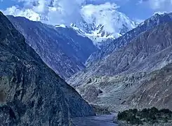
The deepest canyon in the world, the Indus Gorge with Nanga Parbat, the world's 9th highest mountain rising to the south.
References
- Zeitler, Peter K.; Koons, Peter O.; Bishop, Michael P.; Chamberlain, C. Page; Craw, David; Edwards, Michael A.; Hamidullah, Syed; Jam, Qasim M.; Kahn, M. Asif; Khattak, M. Umar Khan; Kidd, William S. F.; Mackie, Randall L.; Meltzer, Anne S.; Park, Stephen K.; Pecher, Arnaud; Poage, Michael A.; Sarker, Golam; Schneider, David A.; Seeber, Leonardo; and Shroder, John F. (October 2001). "Crustal reworking at Nanga Parbat, Pakistan: Metamorphic consequences of thermal-mechanical coupling facilitated by erosion". Tectonics 20 (5): 712–728.
This article is issued from Wikipedia. The text is licensed under Creative Commons - Attribution - Sharealike. Additional terms may apply for the media files.