Indiana's congressional districts
Indiana has nine congressional districts. They were last redrawn after the 2010 census and took effect in 2013, following the 2012 elections. For a history of who has served in each district, see United States congressional delegations from Indiana§House of Representatives.

Current districts and representatives
List of members of the House delegation, their terms in office, district boundaries, and the district political ratings according to the CPVI. The delegation has 9 members: 7 Republicans and 2 Democrats.
| District | Incumbent | District | |||
|---|---|---|---|---|---|
| Member (Residence) |
Party | Tenure | CPVI | Map | |
| 1st |  Frank J. Mrvan (D-Highland) |
Democratic | January 3, 2021 | D+8 | .tif.png.webp) |
| 2nd | .jpg.webp) Jackie Walorski (R-Elkhart) |
Republican | January 3, 2013 | R+11 | .tif.png.webp) |
| 3rd | .jpg.webp) Jim Banks (R-Columbia City) |
Republican | January 3, 2017 | R+18 | .tif.png.webp) |
| 4th | .jpg.webp) Jim Baird (R-Greencastle) |
Republican | January 3, 2019 | R+17 | .tif.png.webp) |
| 5th |  Victoria Spartz (R-Noblesville) |
Republican | January 3, 2021 | R+9 | .tif.png.webp) |
| 6th | .jpg.webp) Greg Pence (R-Columbus) |
Republican | January 3, 2019 | R+18 | .tif.png.webp) |
| 7th | .jpg.webp) André Carson (D-Indianapolis) |
Democratic | March 11, 2008 | D+11 | .tif.png.webp) |
| 8th | .jpg.webp) Larry Bucshon (R-Evansville) |
Republican | January 3, 2011 | R+15 | .tif.png.webp) |
| 9th |  Trey Hollingsworth (R-Jeffersonville) |
Republican | January 3, 2017 | R+13 | .tif.png.webp) |
Members of the House of Representatives are elected every two years by popular vote within a congressional district. Indiana has nine congressional districts—this number is reapportioned based on the state's population, determined every ten years by a census. Indiana had a maximum representation of 13 congressmen from 1873 to 1933. Since 2003 Indiana has had nine representatives, which was reduced from ten after the 2000 census. This gives Indiana the fourteenth-largest delegation; during the period from 1853 to 1873 the state had the fifth-largest delegation.
Historical and present district boundaries
Table of United States congressional district boundary maps in the State of Indiana, presented chronologically.[2] All redistricting events that took place in Indiana between 1973 and 2013 are shown.
| Year | Statewide map | Indianapolis highlight |
|---|---|---|
| 1973–1982 | 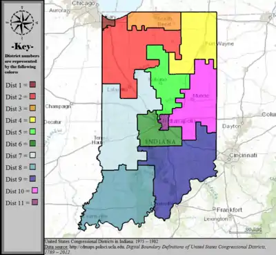 |
%252C_1973_%E2%80%93_1982.tif.png.webp) |
| 1983–1992 |  |
%252C_1983_%E2%80%93_1992.tif.png.webp) |
| 1993–2002 |  |
%252C_1993_%E2%80%93_2002.tif.png.webp) |
| 2003–2013 | 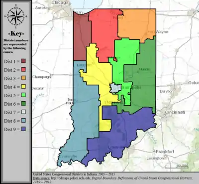 |
%252C_2003_%E2%80%93_2013.tif.png.webp) |
| Since 2013 |  |
%252C_since_2013.tif.png.webp) |
Obsolete districts
- Indiana Territory's at-large congressional district, obsolete since statehood
- Indiana's 10th congressional district, obsolete since 2000 census
- Indiana's 11th congressional district, obsolete since 1980 census
- Indiana's 12th congressional district, obsolete since 1940 census
- Indiana's 13th congressional district, obsolete since 1930 census
- Indiana's at-large congressional district (1816–1823; 1873–1875)
References
- "The National Atlas". nationalatlas.gov. Archived from the original on February 22, 2014. Retrieved February 22, 2014.
- "Digital Boundary Definitions of United States Congressional Districts, 1789–2012". Retrieved October 18, 2014.