Imljani
Imljani (Serbian Cyrillic: Имљани), is a village in Republika Srpska, which is located in the municipality of Kneževo. Since 1954, Imljani was one of local communities of Former Šiprage Municipality in Former Kotor Varoš County.
Imljani | |
|---|---|
 | |
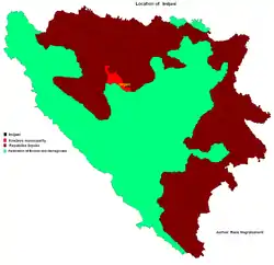 Location of Imljani in Bosnia and Herzegovina | |
| Coordinates: 44°24′02″N 17°29′29″E | |
| Country | Bosnia and Herzegovina |
| Entity | Republika Srpska |
| Municipality | Kneževo |
| Population (1991) | |
| • Total | 1,565 |
| Time zone | UTC+2 (EET) |
| • Summer (DST) | UTC+3 (EEST) |
| Postal code | 78234 |
| Area code(s) | (+387) 51 |
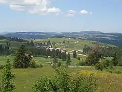
Imljani consists of a few hamlets spreading on the lower vlašić's plateau, above the canyons of Ilomska and Ugar rivers. Actually, it covers the sub-plateau in the area of the angle between Korićanske stijene and Ugarske stijene ("Rocks of Ugar").[1][2][3][4][5][6]
Central hamlet the Vidovište is on (around) 1200 meters above sea level. Around Vidovište, from Kobilja river (south-west) to Ilomska's canyon (north-east) there are the hamlets, as follows - North-eastern: Rijeka, Potok, Ponorci, Osredok, Benići, Škeljići, Pušići, Marići, Đenići and Đekin Do; South-western: Vujinovići, Makarići, Kelemeni, Novakovići, Šodolovići and Borje.
- Traditional women costumes (front and back) in Imljani (Hamlet Grubači, ≈1810)
Ethnic composition, 1991 census
| Ethnic composition of Skender Vakuf municipality, by settlements, 1991. census | ||||||
| settlement | total | Serbs | Muslims | Croats | Yugoslavs | others' |
| Imljani | 1,565 | 1,544 | 3 | 1 | 5 | 12 |
- Demography
| Imljani[7][8] | ||||||
| Census Year | 1991 | 1981 | 1971 | |||
| Serbs | 1,544 (98.65%) | 2,044 (98.83%) | 2,052 (99.37%) | |||
| Bosniaks | 3 (0.19%) | 1 (0.04%) | 0 | |||
| Croats | 1 (0.06%) | 6 (0.29%) | 5 (0.24%) | |||
| Yugoslavians | 5 (0.31%) | 2 (0.09%) | 0 | |||
| Others and unknown | 12 (0.76%) | 15 (0.72%) | 8 (0.38%) | |||
| Total | 1,565 | 2,068 | 2,065 | |||
See also
References
- http://www.kartabih.com/
- Vojnogeografski institut, Izd. (1955): Travnik (List karte 1:100.000, Izohipse na 20 m). Vojnogeografski institut, Beograd.
- Spahić M. et al. (2000): Bosna i Hercegovina (1:250.000). Izdavačko preduzeće „Sejtarija“, Sarajevo.
- Mučibabić B., ed. (1998). Geografski atlas Bosne i Hercegovine. Sarajevo: Geodetski zavod BiH. ISBN 9958-766-00-0.
- Book: "Nacionalni sastav stanovništva - Rezultati za Republiku po opštinama i naseljenim mjestima 1991.", statistički bilten br. 234, Izdanje Državnog zavoda za statistiku Republike Bosne i Hercegovine, Sarajevo.
- Internet - Source: "Popis po mjesnim zajednicama" - "Archived copy" (PDF). Archived from the original (PDF) on 2013-10-05. Retrieved 2013-02-11.CS1 maint: archived copy as title (link).