Hurricane Caroline
Hurricane Caroline was one of two tropical cyclones to affect northern Mexico during the 1975 Atlantic hurricane season. The third named storm and second hurricane of the season, Caroline developed on August 24 north of the Dominican Republic. The system crossed Cuba and briefly degenerated into a tropical wave due to land interaction. However, upon emergence into the western Caribbean Sea, it was once again designated as a tropical depression after a well-defined circulation was observed on satellite imagery. Moving towards the west-northwest, the cyclone clipped the northern portion of the Yucatán Peninsula before entering the Gulf of Mexico. Caroline was upgraded to a tropical storm on August 29 in the central Gulf of Mexico before rapid intensification began. Early on August 31, Caroline reached its peak intensity with winds of 115 mph (185 km/h), before landfall south of Brownsville, Texas with winds of 105 mph (165 km/h) shortly thereafter. After moving inland, Caroline quickly weakened and dissipated over the mountainous terrain of northeastern Mexico on September 1. There were only two deaths from Caroline, both indirect. However, there was heavy rainfall in southern Texas and Mexico, including almost 12 in (300 mm) at Port Isabel.
| Category 3 major hurricane (SSHWS/NWS) | |
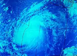
 Hurricane Caroline before landfall | |
| Formed | August 24, 1975 |
|---|---|
| Dissipated | September 1, 1975 |
| Highest winds | 1-minute sustained: 115 mph (185 km/h) |
| Lowest pressure | 963 mbar (hPa); 28.44 inHg |
| Fatalities | 2 indirect |
| Areas affected | Cuba, northern Mexico, Texas |
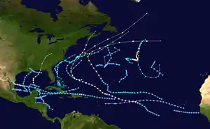
| Part of the 1975 Atlantic hurricane season | |
Meteorological history

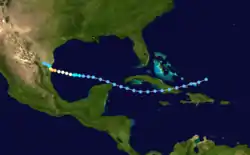
A tropical wave exited the west coast of Africa on August 15 and rapidly moved westward at 17 mph (28 km/h) along the Intertropical Convergence Zone (ITCZ). On August 18, the system turned northeast away from the ITCZ and slowed by the time it was 600 miles (965 km) northeast of Puerto Rico. On August 22 and 23, the system changed course for the second time as it turned to the southwest. By noon on August 24, satellite imagery showed the disturbance establishing a closed area of circulation with winds reaching 25 mph (40 km/h) and the barometric pressure falling to 1,011 millibars (29.9 inHg). The disturbance then became Tropical Depression Five as it neared northeastern Cuba and southeastern Bahamas. It crossed Cuba where it momentarily weakened back to a tropical wave. The cyclone then regained tropical depression status on August 27 as it continued westward into the Gulf of Mexico.[1]

After brushing the northeastern tip of the Yucatán Peninsula, Tropical Depression Five continued to move west at 8 mph (13 km/h) as the storm entered an area favorable for intensification. On August 29, the tropical system strengthened to a tropical storm and was named Caroline by the National Hurricane Center. By that time the storm was only 400 miles (640 km) east-southeast of Brownsville, Texas. Caroline's forward speed slowed to 5 mph (8 km/h) while intensifying and on the same day, Caroline was upgraded to hurricane status.[1] Before making landfall, two hurricane hunter aircraft's flew into Caroline's center on August 30, where data collected from the aircraft showed a barometric pressure reading of 987 millibars (29.1 inHg) and winds of 80 mph (130 km/h). Six hours later the hurricane rapidly intensified, with winds reaching 115 mph (185 km/h) and the pressure dropping to 973 millibars (28.7 inHg).[2] The pressure then fell to 963 millibars (28.4 inHg) before the storm made landfall 100 miles (160 km) south of Brownsville on August 31.[3] Caroline rapidly weakened to a tropical depression twelve hours after landfall and dissipated on September 1 over northeastern Mexico.[4]
Experiments
Two National Oceanic and Atmospheric Administration (NOAA) Research planes conducted experiments into Caroline. The experiments were to study and measure the wind velocity and the environment inside and around the eye as well as the boundary layer of the hurricane. The results of the experiments concluded that Caroline had a higher dissipation rate than normal hurricanes, with the dissipating rate averaging at 30%. This conclusion suggested that energy in a hurricane dissipating internally above the surface layer is two times higher than energy dissipating at the surface.[2]
Preparations and impact

Caroline brushed the southeastern Bahamas and made landfall in eastern Cuba as a tropical depression though its effects, if any, are unknown.[5]
The National Hurricane Center issued a hurricane watch for coastal sections of south Texas and northern Mexico on August 30.[1] Small water craft were also advised of the deteriorating conditions.[6] In Texas, local officials in Cameron County opened storm shelters. Relief and clean up organizations were notified of the upcoming threat while several local oil rigs evacuated personnel.[7] In addition, relief squads from the American Red Cross moved to South Texas in case the storm made landfall.[8] Neil Frank, the director of the National Hurricane Center advised campers along the beaches to evacuate, stating that "he doesn't want them trapped".[6]
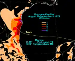
Due to Caroline’s compact size, sustained winds only reached 48 mph (78 km/h) in Brownsville, Texas. The storm also dropped heavy rain the southern portion of the state, as much as 11.93 in (302 mm) in Port Isabel.[9] In Brownsville, Caroline broke a record for most rainfall within a 24-hour period during the month of August.[10] The rainfall caused minor flooding.[3] This helped end a prolonged drought in the Rio Grande Valley. It canceled most of the Labor Day holiday season for South Padre Island, one of the busiest weekends for tourism on the island.[8] Caroline also produced storm tides 1–4 feet (0.3-1.2 m) above normal along coastal sections of southern Texas. Overall damage in southern Texas was minor, and there were two indirect fatalities due to drowning incidents in Galveston.[11]
In Mexico, coastal residents evacuated to storm shelters south of Tampico. Elsewhere, 300 residents were evacuated to storm shelters in Soto la Marina 55 miles (88 km) from Santa Rosa. In northeast Mexico, 150 residents evacuated to shelters in San Fernando, 85 miles (137 km) south of Brownsville. The storm produced 10 feet (3 m) storm tides to coastal sections of Mexico and 5-10 in (127–254 mm) of rain to inland areas. The rainfalls caused moderate flooding which caused 1,000 people to evacuate and left moderate damage to homes and businesses. The rains broke an eight-month drought that was affecting inland areas of northern Mexico that was affecting the area's corn production.[12] Along the coast, several small villages sustained significant damage from the hurricane's storm surge.[3]
See also
References
- "Preliminary Report Hurricane Caroline August 24 - September 1". National Hurricane Center. National Oceanic and Atmospheric Administration. 1975. Retrieved 2014-03-03.
- Francis J. Mercert (1976). "The Turbulent Microstructure of Hurricane Caroline (1975)" (PDF). American Meteorological Society. Retrieved 2007-03-19.
- "Preliminary Report Hurricane Caroline August 24 - September 1". National Hurricane Center. National Oceanic and Atmospheric Administration. 1975. Retrieved 2007-03-20.
- Paul J. Hebert (1976). "Atlantic Hurricane Season of 1975" (PDF). American Meteorological Society. Retrieved 2007-03-20.
- "Tropical Storm Caroline in Gulf, Heading for Texas". The Daytona Beach News-Journal. Associated Press. August 29, 1975. Retrieved 2014-02-26.
- "Hurricane Caroline Perils Mexican Coast and Texas". The Nashua Telegraph. Associated Press. August 30, 1975. Retrieved 2014-02-09.
- "Hurricane Caroline Drifts Near Texas". The Pittsburgh Press. United Press International. August 30, 1975. Retrieved 2013-02-26.
- "Caroline Aims Below Texas; Area Under Hurricane Watch". The Daytona Beach News-Journal. Associated Press. August 30, 1975. Retrieved 2014-02-26.
- David M. Roth (July 6, 2009). "Hurricane Caroline - August 26-September 2, 1975". Weather Prediction Center. Retrieved 2013-01-05.
- "Texas Weather Last Year Seems 'Practically Normal'". The Victoria Advocate. Associated Press. March 2, 1976. Retrieved 4 March 2014.
- "Caroline is Downgraded, Mexico gets only light damage". The Galveston Daily News. United Press International. September 1, 1975.
- "Caroline Downgraded". The Daytona Beach News-Journal. Associated Press. September 1, 1975. Retrieved 2014-02-26.
