Hundred of Bartlett
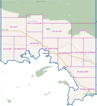
The Hundred of Bartlett is a cadastral hundred of South Australia located in the remote County of Way. It was created in 1889.[1]

Location
It overlooking the Great Australian Bight about 584 kilometres (363 mi) north-west of the Adelaide city centre and about 33 kilometres (21 mi) west of the town centre of Ceduna.[2][3]
By one reading of the book Gulliver's Travels, the hundred is the closest inhabited place to the location of the fictitious island of Lilliput.[4][5]
History
The traditional owners of the area were the Wirangu Aboriginal people and the first European to sight the area was Dutch explorer Pieter Nuyts in 1627 in the Gulden Zeepaard. In 1802 Matthew Flinders came past the district whilst on his voyage in the Investigator,.[6]
The Hundred of Bartlett (together with the Hundreds of Moule, Horn and Catt) were surveyed for closer settlement by William Richard Murray, E B Jones and H J Cant between Nov. 1888 and June 1889.
References
- "Placename Details: Hundred of Bartlett". Property Location Browser. Government of South Australia. 18 November 2016. SA0004886. Retrieved 30 October 2017.
GDA 94 Coordinates: -32.081010, 133.398950 ; Named By: Governor Robinson; Date Named: 17/01/1889; Derivation of Name: H Bartlett MP 1887-1896; Other Details: Area 92 square miles. Bartlett was the Member for the Yorke Peninsula.
- "Placename Details: Charra". Property Location Browser. Government of South Australia. 18 November 2016. SA0013404. Retrieved 30 October 2017.
Date Named: 19/09/1889; Derivation of Name: Charra Homestead, Town Etc; Other Details: Town surveyed in May 1989. Government Town declared ceased to exist on 16/5/1929, however, the name is still recognised in the area. Boundaries created in January 1999 for the long established name. Incorporates the ceased Government Town of Charra.
- "Charra, South Australia (Postcode)". postcodes-australia.com. Retrieved 23 July 2016.
- Bracher, Frederick (1944). "The Maps in 'Gulliver's Travels'". Huntington Library Quarterly. University of California Press. 8 (1): 67–68. JSTOR 3815865.
- Case, Arthur E. (1945). "The Geography and Chronology of Gulliver's Travels". Four Essays on Gulliver's Travels. Princeton: Princeton University Press. pp. 50–68.
- "Streaky Bay: Our History". District Council of Streaky Bay. 2 May 2006. Archived from the original on 29 August 2007. Retrieved 23 June 2007.