Hour angle
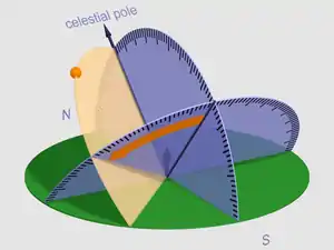
In astronomy and celestial navigation, the hour angle is one of the coordinates used in the equatorial coordinate system to give the direction of a point on the celestial sphere. The hour angle of a point is the angle between two planes: one containing Earth's axis and the zenith (the meridian plane), and the other containing Earth's axis and the given point (the hour circle passing through the point).

The angle may be expressed as negative east of the meridian plane and positive west of the meridian plane, or as positive westward from 0° to 360°. The angle may be measured in degrees or in time, with 24h = 360° exactly.
In astronomy, hour angle is defined as the angular distance on the celestial sphere measured westward along the celestial equator from the meridian to the hour circle passing through a point.[1] It may be given in degrees, time, or rotations depending on the application.
In celestial navigation, the convention is to measure in degrees westward from the prime meridian (Greenwich hour angle, GHA), from the local meridian (local hour angle, LHA) or from the first point of Aries (sidereal hour angle, SHA).
The hour angle is paired with the declination to fully specify the location of a point on the celestial sphere in the equatorial coordinate system.[2]
Relation with the right ascension

Assuming in this example the day of the year is the March equinox so the sun lies in the direction of the grey arrow then this star will rise about midnight. Just after the observer reaches the green arrow dawn comes and overwhelms with light the visibility of the star about six hours before it sets on the western horizon. The Right Ascension of the star is about 18h
The local hour angle (LHA) of an object in the observer's sky is
- or
where LHAobject is the local hour angle of the object, LST is the local sidereal time, is the object's right ascension, GST is Greenwich sidereal time and is the observer's longitude (positive east from the prime meridian).[3] These angles can be measured in time (24 hours to a circle) or in degrees (360 degrees to a circle)—one or the other, not both.
Negative hour angles (-180 < LHAobject < 0) indicate the object is approaching the meridian, positive hour angles (0 < LHAobject < 180) indicate the object is moving away from the meridian; an hour angle of zero means the object is on the meridian.
Solar hour angle
Observing the sun from earth, the solar hour angle is an expression of time, expressed in angular measurement, usually degrees, from solar noon. At solar noon the hour angle is 0.000 degree, with the time before solar noon expressed as negative degrees, and the local time after solar noon expressed as positive degrees. For example, at 10:30 AM local apparent time the hour angle is −22.5° (15° per hour times 1.5 hours before noon).[4]
The cosine of the hour angle (cos(h)) is used to calculate the solar zenith angle. At solar noon, h = 0.000 so cos(h)=1, and before and after solar noon the cos(± h) term = the same value for morning (negative hour angle) or afternoon (positive hour angle), i.e. the sun is at the same altitude in the sky at 11:00AM and 1:00PM solar time, etc.[5]
Sidereal hour angle
The sidereal hour angle (SHA) of a body on the celestial sphere is its angular distance west of the vernal equinox generally measured in degrees.
An alternate definition is that SHA of a celestial body is the arc of the Equinoctial or the angle at the celestial pole contained between the celestial meridian of the First point of Aries and that through the body, measured westward from Aries.
The SHA of a star changes slowly, and the SHA of a planet doesn't change very quickly, so SHA is a convenient way to list their positions in an almanac. SHA is often used in celestial navigation and navigational astronomy.
See also
Notes and references
- U.S. Naval Observatory Nautical Almanac Office (1992). P. Kenneth Seidelmann (ed.). Explanatory Supplement to the Astronomical Almanac. Mill Valley, CA: University Science Books. p. 729. ISBN 0-935702-68-7.
- Explanatory Supplement (1992), p. 724.
- Meeus, Jean (1991). Astronomical Algorithms. Willmann-Bell, Inc., Richmond, VA. p. 88. ISBN 0-943396-35-2.
- Kreider, J. F. (2007). "Solar Energy Applications". Environmentally Conscious Alternative Energy Production. pp. 13–92. doi:10.1002/9780470209738.ch2. ISBN 9780470209738.
- Schowengerdt, R. A. (2007). "Optical radiation models". Remote Sensing. pp. 45–88. doi:10.1016/B978-012369407-2/50005-X. ISBN 9780123694072.