Gim Jeong-ho
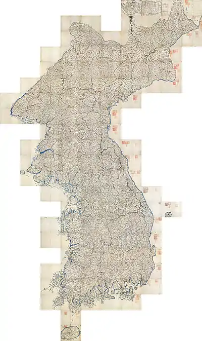
Kim Jeong-ho (pen name Gosanja; ‘the guy of old mountain’ 1804–1866?) was a Korean geographer and cartographer. He was born in Hwanghaedo. It is believed that he walked the entire length and breadth of the Korean peninsula, through mountain and valley, in order to research and compile his magnum opus, the Daedongyeojido, (대동여지도, 大東輿地圖) a map of Korea that was published in 1861, from which was subsequently made a single-sheet version, the Daedongyeojijeondo (대동여지전도 大東與地全圖).
| Gim Jeong-ho | |
| Hangul | 김정호 |
|---|---|
| Hanja | 金正浩 |
| Revised Romanization | Gim Jeongho |
| McCune–Reischauer | Kim Chŏngho |
| Pen name | |
| Hangul | 고산자 |
| Hanja | 古山子 |
| Revised Romanization | Gosanja |
| McCune–Reischauer | Kosanja |
| Courtesy name | |
| Hangul | 백원 or 백온 |
| Hanja | 伯元 or 伯溫 |
| Revised Romanization | Baegwon, or Baegon |
| McCune–Reischauer | Paegwŏn, or Paegon |
| [kim dʑʌŋho, koːsʰandʑa, pɛɡwʌn/pɛɡon] | |

The events surrounding Kim's death are obscure. Following the publication of a later version of the Daedong Yeojido in 1866. Kim is not heard from again. The document from the Governor-General of Korea asserts that the Korean regent Daewongun, upon viewing the later version of Kim's great map, became incensed by its inclusion of details of a sensitive nature critical to national defense. According to the document, the Daewongun had Kim arrested and jailed and the maps had been destroyed.[1]
However, this is not true, as the original wood printing block of Daedong Yeojido still can be found in the Soongsil University and also in the Korea University. Furthermore, the people who helped to develop the map such as Choe Han-gi and Shin Hun was not convicted at all. The Korean historical community believes that the document was a fabrication by the General-Government, which was under control by Japan during Japanese colonization.[2]
The asteroid 95016 Kimjeongho is named in his honour.
Gallery
 Daedong Yeoji Jeondo
 Daedong Yeoji Jeondo, another version
 Yeoji Jeondo
 Suseon jeondo
 Dongyeodo
See also
References
- General-Government of Korea, 〈조선어 독본 5〉, 1934, page 23 ~ 24
- Lee Sang-tae, 〈고산자 김정호의 생애와 사상〉, 1991, page 141
Further reading
- Kane, Daniel C. (2003), “Martyr to a Map: the Inscrutable Father of Korean Cartography”. Mercator’s World, Vol. 8, No. 1 (January/February 2003).
- Cope, Angela (2009), "Korean National Treasure Identified in AGS Library." UWM Libraries Newsletter, Fall 2009, No. 56.
- Ledyard, Gari (1994) "Cartography in Korea." The History of Cartography, Vol. 2, Book 2, (Ledyard includes a good biography of Kim with description of his contribution to cartography in Korea and Asia).