Fordon, East Riding of Yorkshire
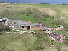
Fordon is a village in the East Riding of Yorkshire, England, near the border with North Yorkshire. It is situated approximately 8 miles (13 km) south of Scarborough and 10 miles (16 km) north-west of Bridlington.
| Fordon | |
|---|---|
 View of Fordon | |
 Fordon Location within the East Riding of Yorkshire | |
| OS grid reference | TA050751 |
| • London | 185 mi (298 km) S |
| Civil parish | |
| Unitary authority | |
| Ceremonial county | |
| Region | |
| Country | England |
| Sovereign state | United Kingdom |
| Post town | DRIFFIELD |
| Postcode district | YO25 |
| Dialling code | 01262 |
| Police | Humberside |
| Fire | Humberside |
| Ambulance | Yorkshire |
| UK Parliament | |
It forms part of the civil parish of Wold Newton.
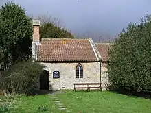
There is a small church dedicated to St James that is now a Grade II* listed building.[1]

St James' Church
The name Fordon, first attested in the Domesday Book of 1086 as Fordun, Fordune, and Forduna, is thought to come from the Old English words fore ('in front of') and dūn ('hill'). Thus it once meant 'In front of the hill'.[2]
In 1823 Fordon was in the parish of Hunmanby and the Wapentake of Dickering. Occupations at the time included three farmers.[3]
References
- Historic England. "Church of St James (1162675)". National Heritage List for England. Retrieved 24 January 2013.
- Smith, A. H. (1937). The Place-Names of The East Riding of Yorkshire and York (PDF). English Place-Name Society, 14. Cambridge University Press.
- Baines, Edward (1823). History, Directory and Gazetteer of the County of York. p. 207.
- Gazetteer — A–Z of Towns Villages and Hamlets. East Riding of Yorkshire Council. 2006. p. 5.
External links
 Media related to Fordon at Wikimedia Commons
- Historic England. "St James' Church (1162675)". National Heritage List for England.
- Fordon in the Domesday Book
This article is issued from Wikipedia. The text is licensed under Creative Commons - Attribution - Sharealike. Additional terms may apply for the media files.