Florida State Road 430
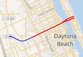
State Road 430 (SR 430) is an east–west state highway in Daytona Beach, running between SR 483/Clyde Morris Boulevard and SR A1A/Atlantic Avenue.
| ||||
|---|---|---|---|---|

SR 430 in red, CR 430 in blue | ||||
| Route information | ||||
| Maintained by FDOT | ||||
| Length | 3.353 mi[1] (5.396 km) | |||
| Major junctions | ||||
| West end | ||||
| East end | ||||
| Location | ||||
| Counties | Volusia | |||
| Highway system | ||||
| ||||
West of the Halifax River, the route runs along Mason Avenue; the Seabreeze Bridge over the river is a dual span connecting to a one-way pair on the beachside, with Oakridge Boulevard eastbound and Seabreeze Boulevard westbound.
West of SR 430's western terminus, Mason Avenue continues for 1.873 miles (3.014 km) as County Road 430 (CR 430) to Williamson Boulevard (CR 4009).[2]
Major intersections

Seabreeze Bridge
The entire route is in Volusia County.
| Location | mi[1] | km | Destinations | Notes | |
|---|---|---|---|---|---|
| Daytona Beach | 0.000 | 0.000 | |||
| 0.988 | 1.590 | ||||
| Daytona Beach–Holly Hill line | 2.069 | 3.330 | |||
| Daytona Beach | 2.474– 2.908 | 3.982– 4.680 | Seabreeze Bridge over Halifax River (Atlantic Intracoastal Waterway) | ||
| 3.353 | 5.396 | ||||
| 1.000 mi = 1.609 km; 1.000 km = 0.621 mi | |||||
References
- FDOT straight line diagrams Archived March 6, 2014, at the Wayback Machine, accessed March 2014
- "County Roads TDA". FDOT. Retrieved April 18, 2020.
This article is issued from Wikipedia. The text is licensed under Creative Commons - Attribution - Sharealike. Additional terms may apply for the media files.
