Florida State Road 267
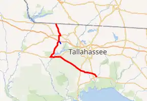
State Road 267 (SR 267) is a north–south state route in the eastern Florida panhandle, west of Tallahassee.
| ||||
|---|---|---|---|---|

SR 267 in red, CR 267A in blue | ||||
| Route information | ||||
| Maintained by FDOT | ||||
| Length | 59.478 mi[1] (95.721 km) | |||
| Major junctions | ||||
| South end | ||||
| North end | ||||
| Location | ||||
| Counties | Wakulla, Leon, Liberty, Gadsden | |||
| Highway system | ||||
| ||||
The route begins at U.S. Route 98 (US 98) in Newport and heads northwest as it crosses SR 363, passes Wakulla Springs, crosses US 319, and continues through the Apalachicola National Forest. It briefly joins with SR 20 to cross the Ochlockonee River, then splits to continue northward to Interstate 10 (I-10), US 90 in Quincy, and the Georgia state line, where it continues as State Route 302.
Major intersections
| County | Location | mi[1] | km | Destinations | Notes |
|---|---|---|---|---|---|
| Wakulla | Newport | 0.000 | 0.000 | ||
| Wakulla | 3.765 | 6.059 | |||
| 3.880 | 6.244 | ||||
| | 8.820 | 14.194 | |||
| | 12.204 | 19.640 | |||
| Hilliardville | 14.865 | 23.923 | |||
| Leon | | 16.690 | 26.860 | Helen Guard Station Road | former SR 267A east |
| Bloxham | 30.790 | 49.552 | south end of SR 20 overlap | ||
| | 31.193 | 50.200 | |||
| Ochlockonee River | 32.38 | 52.11 | Bridge | ||
| Liberty | | 32.680 | 52.593 | ||
| | 34.334 | 55.255 | north end of SR 20 overlap | ||
| Gadsden | | 41.602 | 66.952 | ||
| Wetumpka | 42.342 | 68.143 | |||
| | 46.425 | 74.714 | |||
| | 46.69 | 75.14 | Exit 181 (I-10) | ||
| Quincy | 49.446 | 79.576 | |||
| 50.147 | 80.704 | south end of US 90 / SR 10 overlap | |||
| 50.990 | 82.060 | north end of US 90 / SR 10 overlap | |||
| | 52.423 | 84.367 | |||
| | 55.246 | 88.910 | |||
| | 55.625 | 89.520 | |||
| | 56.463 | 90.868 | |||
| | 59.478 | 95.721 | Georgia state line | ||
| 1.000 mi = 1.609 km; 1.000 km = 0.621 mi | |||||
County Road 267A
| |
|---|---|
| Location | Gadsden County |
County Road 267A is the only suffixed alternate of SR 267. The road is named Spooner Road and can be found south of Quincy. It begins south of the interchange with I-10 and runs southeast to County Road 65B (Old Federal Highway).
References
- FDOT straight line diagrams Archived March 6, 2014, at the Wayback Machine, accessed February 2014
External links
 Media related to Florida State Road 267 at Wikimedia Commons
- Florida Route Log (SR 267)
- FDOT Maps of Wakulla, Leon, Liberty, and Gadsden Counties (including SR 267)
- Big Bend Scenic Byway (Florida Scenic Highways)
This article is issued from Wikipedia. The text is licensed under Creative Commons - Attribution - Sharealike. Additional terms may apply for the media files.
