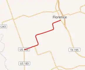
Farm to Market Road 970
Farm to Market Road 970 (FM 970) is a highway in Texas. It runs about 8.6 miles (13.8 km) from Florence southwestward through Andice until it intersects US 183. The road was designated in 1948.
| ||||
|---|---|---|---|---|

| ||||
| Route information | ||||
| Length | 8.061 mi[1] (12.973 km) | |||
| Existed | 1948–present | |||
| Major junctions | ||||
| West end | ||||
| East end | ||||
| Highway system | ||||
| ||||
Route description
FM 970 begins at an intersection with US 183 in Williamson County, heading east-northeast on a two-lane undivided road. The road heads through open farmland with some homes, passing through the community of Andice. The highway passes through an area of woods, crossing South Berry Creek, and turns to the north-northwest, heading into more agricultural areas. FM 970 curves to the east-northeast again and heads through more farm fields with some residences before crossing Berry Creek in woodland. The road heads back into areas of agriculture and turns north-northwest again. The highway makes another turn to the east-northeast in a wooded area and heads through areas of fields, trees, and homes, crossing into Florence. FM 970 comes to its eastern terminus at an intersection with SH 195.[1][2][3]
History
FM 970 was designated onto its current alignment on November 23, 1948, running from SH 74 (now US 183) to SH 195. The routing has not changed since.[1]
Major intersections
The entire route is in Williamson County.
| Location | mi[1] | km | Destinations | Notes | |
|---|---|---|---|---|---|
| Andice | 0.000 | 0.000 | |||
| Florence | 8.061 | 12.973 | |||
| 1.000 mi = 1.609 km; 1.000 km = 0.621 mi | |||||
References
- Transportation Planning and Programming Division (n.d.). "Farm to Market Road No. 970". Highway Designation Files. Texas Department of Transportation.
- Google (October 27, 2011). "overview map of Farm to Market Road 970" (Map). Google Maps. Google. Retrieved October 27, 2011.
- County Grid Map 429 (PDF) (Map). Texas Department of Transportation. 2010. Archived from the original (PDF) on June 12, 2012. Retrieved October 27, 2011.
