Farm to Market Road 2972
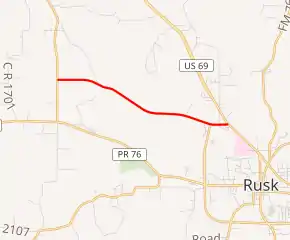
Farm to Market Road 2972 (FM 2972) is a state-maintained farm to market road in Cherokee County, Texas. It runs about 3.67 miles (5.91 km) from an intersection with FM 347 south of Dialville, east to an intersection with U.S. Highway 69 (US 69) in Rusk.
| ||||
|---|---|---|---|---|

| ||||
| Route information | ||||
| Length | 3.67 mi[1] (5.91 km) | |||
| Existed | 1970[1]–present | |||
| Major junctions | ||||
| West end | ||||
| East end | ||||
| Location | ||||
| Counties | Cherokee | |||
| Highway system | ||||
| ||||
The present version of FM 2972 was designated in 1970, though it is unclear as to when the road was completed. A previous highway with the same number existed in San Jacinto County between 1965 and 1969. This route was combined with FM 222.
Route description
FM 2972 begins at FM 347 at Delmer, south of Dialville. It continues to an intersection with FM 343. FM 2972 then passes by two Texas Department of Criminal Justice facilities before ending at an intersection with US 69.[2]
FM 2972 has no local street names. Rural for much of its length, except in the vicinity of its eastern terminus, the landscape along the road includes rolling hills of alternating open pastures and trees. The entire road has 2 lanes and no shoulders.[2]
History
First designation
The first FM 2972 was created on June 1, 1965. Located in San Jacinto County, it ran from Shepherd northward for 0.7 miles (1.1 km). The route was extended northward by 1.2 miles (1.9 km) on July 11, 1968. On December 12, 1969, the designation was canceled and the route was combined with FM 222.[1]
Current designation
The present designation of FM 2972 was created on May 7, 1970, along the present alignment.[1]
Major intersections
The entire route is in Cherokee County.
| Location | mi[2] | km | Destinations | Notes | |
|---|---|---|---|---|---|
| | 0.0 | 0.0 | Western terminus | ||
| Rusk | 3.3 | 5.3 | |||
| 3.7 | 6.0 | Eastern terminus | |||
| 1.000 mi = 1.609 km; 1.000 km = 0.621 mi | |||||
References
- Transportation Planning and Programming Division (n.d.). "Farm to Market Road No. 2972". Highway Designation Files. Texas Department of Transportation. Retrieved May 30, 2018.
- Google (May 30, 2018). "Map of FM 2972" (Map). Google Maps. Google. Retrieved May 30, 2018.
