Fall (Lenggries)
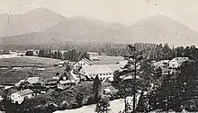
Fall is, or was respectively, a small village (Kirchdorf) in the Lenggries[1] municipality in Landkreis Bad Tölz-Wolfratshausen, Upper Bavaria, Germany. It is located on an peninsula of Lake Sylvenstein.


It is named after Faller Klamm,[2] which is located northward. Older names were Am Fall oder Zum Faal. The village is mentioned first in 1280 as a farm house.
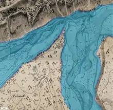
In 1954, the old village was abandoned because of the construction of Sylvenstein Dam (Sylvensteinspeicher). The village was flooded intentionally in 1959. A newly built village with the same name was created at a height of 773 metres[3] and 100 metres away from the former location.
As of March 20, 2015 the village had a population of 111. The village is connected via Bundesstraße 307. A road bridge (built in 1959) named Faller-Klamm-Brücke spans over the lake starting in the northeast and has a length of 329 metres.
Literature
- Ludwig Ganghofer, Der Jäger von Fall. 1883. (Onlinefassung) (in German)
- Anton Böhm, Fall – Das versunkene Dorf. Selbstverlag, Rottach-Egern 2003. (in German)
- Anton Böhm, Fall – das Dorf und der Speicher (das Schicksal eines Dorfes). Selbstverlag, Rottach-Egern 2008. (in German)
- Stephan Bammer (Hrsg.): Die obere Isar - eine Zeitreise: Alt-Fall, Neu-Fall, Sylvensteinspeicher. Eder-Verlag, Lenggries 1997, ISBN 3-9805665-2-8. (in German)
- Vasco Boenisch, Martina Farmbauer, Versunkene Erinnerungen. Vor fünfzig Jahren verschwand ein ganzer Ort. In: Süddeutsche Zeitung. 14. November 2003. (in German)
- Neu-Fall, Oberbayern. In: Baumeister. Band 57, 1960, S. 540 f. (ISSN 0005-674X) (in German)
- Ein versunkenes Dorf taucht wieder auf. In: Süddeutsche Zeitung. 5. Dezember 2015. (in German)
External links
![]() Media related to Fall (Lenggries) at Wikimedia Commons
Media related to Fall (Lenggries) at Wikimedia Commons
References
- distance: 14 km
- Barbara Schwarz: Der Isarwinkel und Bad Tölz. Volk Verlag, München 2010, ISBN 978-3-937200-90-3, S. 30. (in German)
- BayernAtlas