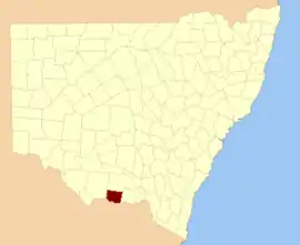
Denison County

Denison County is one of the 141 Cadastral divisions of New South Wales. It contains the towns of Barooga and Berrigan.

Denison
New South Wales
Location in New South Wales
Lands administrative divisions around Denison:
Townsend Urana Urana
Townsend Denison Hume
Moira (Vic) Moira (Vic) Bogong (Vic)

Denison County was named in honour of the Governor-General of New South Wales, Sir William Thomas Denison (1804-1871).[1]

Parishes within this county

Denison County NSW as shown on John Sands 1886 map)[2]

A full list of parishes found within this county; their current LGA and mapping coordinates to the approximate centre of each location is as follows:

ParishLGACoordinates
BaroogaBerrigan Shire Council35°49′54″S 145°40′04″E
BerriganBerrigan Shire Council35°33′54″S 145°44′04″E
BoomanoomanaBerrigan Shire Council35°54′54″S 145°54′04″E
Bull PlainFederation Council35°44′54″S 146°10′04″E
CarlyleBerrigan Shire Council35°49′54″S 145°54′04″E
Coreen WestFederation Council35°38′54″S 146°14′04″E
CottadiddaBerrigan Shire Council35°54′54″S 145°45′04″E
DenisonFederation Council35°47′54″S 146°09′04″E
Dry ForestFederation Council30°52′54″S 146°10′04″E
FinleyBerrigan Shire Council35°38′54″S 145°36′04″E
GerelderyBerrigan Shire Council35°41′54″S 145°49′04″E
HeadfordBerrigan Shire Council35°44′54″S 145°42′04″E
KilnyanaBerrigan Shire Council35°45′54″S 145°55′04″E
LalaltyBerrigan Shire Council35°50′54″S 145°46′04″E
LangunyaBerrigan Shire Council35°43′54″S 145°36′04″E
MomolongFederation Council35°35′54″S 146°00′04″E
MulwalaFederation Council35°55′54″S 146°01′04″E
NanguniaBerrigan Shire Council35°45′54″S 145°48′04″E
Narrow PlainsFederation Council35°37′54″S 146°04′04″E
OsborneBerrigan Shire Council35°36′54″S 145°50′04″E
SargoodBerrigan Shire Council35°32′54″S 145°38′04″E
SavernakeFederation Council35°45′54″S 146°01′04″E
TocumwalBerrigan Shire Council35°46′54″S 145°33′04″E
TongabooBerrigan Shire Council35°32′54″S 145°34′04″E
TurramiaFederation Council35°56′54″S 146°07′04″E
UlupnaBerrigan Shire Council35°37′54″S 145°33′04″E
WahgunyahFederation Council35°50′54″S 146°02′04″E
WangamongFederation Council35°37′54″S 146°08′04″E
WarmattaBerrigan Shire Council35°41′54″S 145°55′04″E
WarragubograBerrigan Shire Council35°38′54″S 145°42′04″E
WoperanaBerrigan Shire Council35°41′54″S 145°30′04″E

References

  1. "Denison". Geographical Names Register (GNR) of NSW. Geographical Names Board of New South Wales. Retrieved 4 August 2013.
  2. The New atlas of Australia (John Sands 1886) map 21.
This article is issued from Wikipedia. The text is licensed under Creative Commons - Attribution - Sharealike. Additional terms may apply for the media files.