Crosby Garrett
Crosby Garrett is a hamlet and civil parish in the Eden District of Cumbria, England. It was formerly in the county of Westmorland.
| Crosby Garrett | |
|---|---|
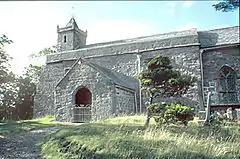
 St. Andrew's Church | |
 Crosby Garrett Location within Cumbria | |
| Population | 195 (2011{including Waitby})[1] |
| OS grid reference | NY7209 |
| Civil parish |
|
| District | |
| Shire county | |
| Region | |
| Country | England |
| Sovereign state | United Kingdom |
| Post town | KIRKBY STEPHEN |
| Postcode district | CA17 |
| Dialling code | 01768 |
| Police | Cumbria |
| Fire | Cumbria |
| Ambulance | North West |
| UK Parliament | |
The place-name 'Crosby Garrett' is first attested in a document of 1200, where it appears as Crosseby, and in another of 1206, where it appears as Crossebi Gerard. The first name is Old Scandinavian Krossa-byr, meaning 'village or homestead with crosses'. 'Garrett' is the French personal name 'Gerard', which is ultimately of Germanic origin.[2]
In May 2010 the Crosby Garrett Helmet, a copper alloy parade helmet dating to Roman Britain, was discovered near the hamlet by a father and son using a metal detector. The helmet was sold to a private buyer at Christie's later that year for £2.3 million.
Description
The parish contains no settlements of any size other than the village of Crosby Garrett, and much of the parish is on Crosby Garrett Fell to the south-west of the village.
The Settle to Carlisle railway passes through the parish, at the southwestern edge of the village on the 110 yd (100 m) Crosby Garrett viaduct;[3] the village once had a railway station, Crosby Garrett station, which closed in 1952.[4]
The parish church of St. Andrew has an Anglo-Saxon chancel, the remainder of the church dates between the 12th and 15th centuries. In 2010, a major restoration project was undertaken.[5]
The highest point in the parish is Nettle Hill at 382 m (1,253 ft). 54.4642°N 2.4384°W
Crosby Garrett Helmet
In May 2010 a rare ceremonial Roman helmet was discovered by an unnamed metal detectorist not far from a Roman road near the hamlet. The copper-alloy helmet with integral mask, with the appearance of a youthful male face, and a griffin crest, is only one of three recorded finds of its kind in Britain.[6]
See also
- Listed buildings in Crosby Garrett
- Smardale within the civil parish of Waitby which forms the eastern boundary of the parish.
References
- "Parish population 2011". Retrieved 22 June 2015.
- Eilert Ekwall, The Concise Oxford Dictionary of English Place-names, p.132.
- "The Settle and Carlisle Railway : Ais Gill to Appleby". www.railwayphotos.net. Crosby Garrett. Archived from the original on 26 July 2010.
- Daniels, Gerald David; Dench, Leslie Alan (February 1963) [1962]. Passengers No More 1952–1962. Closures of stations and branch lines (PDF) (2nd ed.). Brighton: GLO. p. 11. OCLC 504319235.
- "Crosby Garrett - St Andrew's Church". www.visitcumbria.com. Archived from the original on 23 May 2011.
- "Rare Roman helmet and face-mask discovered". www.telegraph.co.uk. 13 September 2010.
External links
| Wikimedia Commons has media related to Crosby Garrett. |
- John F Curwen (1932). "The Later Records relating to North Westmorland: or the Barony of Appleby, pp.110-114". www.british-history.ac.uk. Parishes (East Ward): St Andrew, Crosby Garrett.
- "Conservation areas list". www.eden.gov.uk. Eden District Council. Crosby Garrett. Archived from the original on 5 March 2012.
- "Crosby Garrett". www.genuki.org.uk.