Craigentinny
Craigentinny (Scottish Gaelic: Creag an t-Sionnaich) is a suburb in the north-east of Edinburgh, Scotland, east of Restalrig and close to Portobello.
Craigentinny
| |
|---|---|
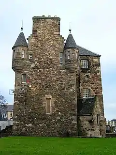
 Craigentinny House | |
 Craigentinny Location within Edinburgh | |
| OS grid reference | NT291749 |
| Council area | |
| Country | Scotland |
| Sovereign state | United Kingdom |
| Post town | EDINBURGH |
| Postcode district | EH7 |
| Dialling code | 0131 |
| Police | Scotland |
| Fire | Scottish |
| Ambulance | Scottish |
| UK Parliament | |
| Scottish Parliament | |
Its name is a corruption of the Scottish Gaelic Creag an t-Sionnaich meaning "Foxrock" or Creag an teine meaning "Fire Crag".
History

Previously moorland, the first major house was built in 1604. This house, Craigentinny Castle (later renamed Craigentinny House), gives its name to the wider area. It was built by James Nisbet of the Nisbet family associated more strongly with the Dean area of the city, as the occupants of Dean House. The land was bought from the Logan family of Restalrig.[1] It was bought around 1760 by William Miller. In 1849/50 it was remodelled by David Rhind for Christie Miller, William Miller's great nephew (who gives his name to Christiemiller Avenue).[2]
In 1932 the Council developed part of the area with 520 houses and a block of six shops in three-storey tenements by Ebenezer James MacRae and his team.
The area contains churches and schools from the 1930s, including, Craigentinny Primary School on Loaning Road which was designed by Ebenezer James MacRae (1935), and St Christophers Church which is at the junction of Craigentinny Road and Craigentinny Avenue and was designed by James MacLachlan (1934).
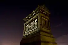
The most distinctive and unique structure in the Craigentinny Marbles, a mausoleum to William Henry Miller (1789–1848) by David Rhind with bas reliefs by Sir Alfred Gatley. The monument was subsumed by bungalows in the 1930s and now stands on Craigentinny Crescent.
Ethnicity
| Craigentinny compared | Craigentinny | Edinburgh |
|---|---|---|
| White | 93.5% | 91.7% |
| Asian | 4.3% | 5.5% |
| Black | 0.9% | 1.2% |
| Mixed | 0.8% | 0.9% |
| Other | 0.5% | 0.8% |
Other features
Craigentinny Golf Course is an 18-hole par 67 course lying on the north edge of the district close to Seafield and the Firth of Forth.[3]
Craigentinny train maintenance depot is located in the area.
References
- "Home". Edinburgh Past And Present. Archived from the original on 26 October 2016. Retrieved 11 February 2018.
- Buildings of Scotland: Edinburgh by Gifford, McWilliam and Walker
- "Craigentinny Golf Course :: Edinburgh Leisure". edinburghleisure.co.uk. Retrieved 11 February 2018.
