Crag Group
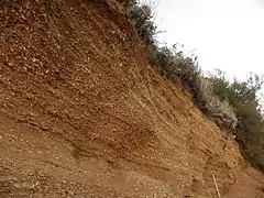
The Crag Group is a geological group outcropping in East Anglia, UK and adjacent areas of the North Sea. Its age ranges from approximately 4.4 to 0.478 million years BP, spanning the late Pliocene and early to middle Pleistocene epochs.[1][2] It comprises a range of marine and estuarine sands, gravels, silts and clays deposited in a relatively shallow-water, tidally-dominated marine embayment on the western margins of the North Sea basin. The sands are characteristically dark green from glauconite but weather bright orange, with haematite 'iron pans' forming. The lithology of the lower part of the Group is almost entirely flint. The highest formation in the Group, the Wroxham Crag, contains over 10% of far-travelled lithologies, notably quartzite and vein quartz from the Midlands, igneous rocks from Wales, and chert from the Upper Greensand of southeastern England. This exotic rock component was introduced by rivers such as the Bytham River and Proto-Thames.[3][4]
| Crag Group Stratigraphic range: Plio-Pleistocene ~4.4–0.78 Ma | |
|---|---|
 Red Crag Formation at Bawdsey cliff, Suffolk | |
| Type | Geologic group |
| Unit of | Great Britain Superficial Deposits Supergroup |
| Sub-units | Coralline, Red, Norwich & Wroxham Crag Formations |
| Underlies | Dunwich, Albion Glacigenic, Britannia Catchments & British Coastal Deposits Groups |
| Overlies | Unconformity with Chalk Group and London Clay Formation |
| Thickness | Up to 70 m (230 ft) offshore |
| Lithology | |
| Primary | Sand |
| Other | Gravel, clay, silt, calcarenite |
| Location | |
| Region | East Anglia |
| Country | |
| Extent | East Anglia & North Sea |
| Type section | |
| Named by | R.C. Taylor |
| Year defined | 1823 |
The constituent formations of the Crag Group are the Coralline Crag (mid to late Pliocene); the Red Crag (late Pliocene / early Pleistocene); the Norwich Crag (early Pleistocene) and the Wroxham Crag (early to Middle Pleistocene).[5] The sedimentary record is incomplete, leading to difficulties in correlating and dating sequences[6]
The term Crag was first used in a geological sense by R.C. Taylor in 1823, a word commonly used in Suffolk to designate any shelly sand or gravel.[7]
References
- Head, MJ (1988). Marine environmental change in the Pliocene and early Pleistocene of eastern England: the dinoflagellate evidence reviewed. In: van Kolfschoten, T and Gibbard, PL (eds): The Dawn of the Quaternary - proceedings of the SEQS-EuroMam Symposium : Kerkrade, 16-21 June 1996. Netherlands Institute of Applied Geoscience, 1998; fig.2. ISBN 9072869613.
- Mathers, SJ & Hamblin, RJO (2015). Late Pliocene and Pleistocene Marine Deposits. In: Lee, JR; Woods, MA; Moorlock, BSP, eds. British Regional Geology: East Anglia (5th Edition). British Geological Survey; fig.46. ISBN 978 085272 823 9
- The BGS Lexicon of Named Rock Units. British Geological Survey; online at http://www.bgs.ac.uk/Lexicon/lexicon.cfm?pub=CRAG. Accessed October 2017
- Lee, JR; Woods, MA; Moorlock, BSP, eds. (2015). British Regional Geology: East Anglia (5th Edition). British Geological Survey; p.110. ISBN 978 085272 823 9.
- Lee, JR; Woods, MA; Moorlock, BSP, eds. (2015). British Regional Geology: East Anglia (5th Edition). British Geological Survey; p.111. ISBN 978 085272 823 9.
- Jones, RL & Keen, DH (1993). Pleistocene Environments of the British Isles. Chapman & Hall. ISBN 0 412 44190 X.
- Woodward, HB (1881): The Geology of the Country around Norwich. Memoirs of the Geological Survey of the United Kingdom; p.32