Colorado State Highway 89
State Highway 89 (SH 89) is a 34.340-mile-long (55.265 km) state highway in the rural eastern plains of Colorado. SH 89's southern terminus is at SH 116 at Buckeye Crossroads, and the northern terminus is at U.S. Route 50 (US 50) and US 400 in Holly.
| ||||
|---|---|---|---|---|
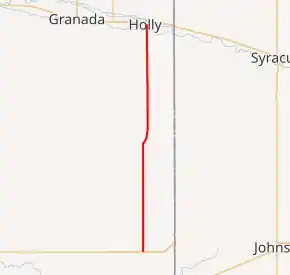
SH 89 highlighted in red | ||||
| Route information | ||||
| Maintained by CDOT | ||||
| Length | 34.340 mi[1] (55.265 km) | |||
| Major junctions | ||||
| South end | ||||
| North end | ||||
| Location | ||||
| Counties | Baca, Prowers | |||
| Highway system | ||||
Colorado State Highways
| ||||

Route description
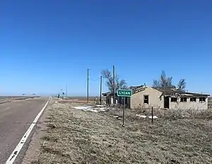
State Highway 89 in Lycan
SH 89 begins in the north at the junction with US 50/400 in Holly and proceeds south out of Holly through rural countryside, isolated from any other towns. Although the highway is the main route from the unincorporated town of Lycan to Holly, there are no major junctions. The highway comes to a stop at the intersection with SH 116 at the small community of Buckeye Crossroads (population: 7). The road continues as an unpaved county road further south after the intersection.
Major intersections
| County | Location | mi[1] | km | Destinations | Notes |
|---|---|---|---|---|---|
| Baca | Buckeye Crossroads | 0.000 | 0.000 | Southern terminus | |
| Prowers | Holly | 34.340 | 55.265 | Northern terminus | |
| 1.000 mi = 1.609 km; 1.000 km = 0.621 mi | |||||
References
- "Segment Descriptions for Highway 89". Colorado Department of Transportation. Retrieved 2008-11-25.
This article is issued from Wikipedia. The text is licensed under Creative Commons - Attribution - Sharealike. Additional terms may apply for the media files.