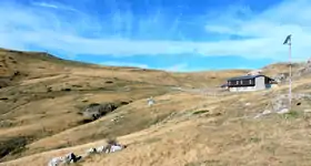
Colle dei Signori
The Colle dei Signori (in Italian) or Col des Seigneurs (in French) at 2,107 m is a mountain pass in the Ligurian Alps. It connects the valleys of Roya in France and Tanaro in Italy.
| Colle dei Signori | |
|---|---|
| Col des Seigneurs | |
 View from the Italian side | |
| Elevation | 2,107 m (6,913 ft)[1] |
| Traversed by | former military dirt road |
| Location | Piedmont, Italy Provence-Alpes-Côte d'Azur, France |
| Range | Ligurian Alps |
| Coordinates | 44°09′30″N 7°40′17″E |
 Colle dei Signori Location of the pass | |
Geography

The Colle dei Signori is located on the main chain of the Alps between the Cime de Capoves and Cima di Gaina. It connects the basins of the Ligurian Sea (West of the pass) and the River Po. Administratively is located between Italian municipality of Briga Alta and one exclave of the French municipality of La Brigue.[1]
History
The pass up to World War II was totally in Italian territory but, following the Paris Peace Treaties, signed in February 1947, is now on the border between Italy and France.[2]
Cicling
The pass in easily accessible with a mountain bike by following the old military road.[3]
References
![]() Media related to Colle dei Signori at Wikimedia Commons
Media related to Colle dei Signori at Wikimedia Commons
- Official map by Institut géographique national, on-line: www.geoportail.gouv.fr
- Treaty text on "Trattato di pace tra Italia ed Alleati". www.instoria.it (in Italian). Retrieved 2017-11-25.
- "Saccarello (Monte) da la Brigue per Col Linaire, Baisse de Sanson, Colle dei Signori". www.gulliver.it (in Italian). Retrieved 2017-11-25.