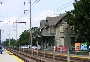
Clifton–Aldan station
Clifton–Aldan station is a SEPTA station in Clifton Heights, Pennsylvania. It serves the Media/Elwyn Line and is nearby the Clifton–Aldan station of the SEPTA Route 102 trolley. It is located at Springfield Road and West Maryland Avenue[2][3] and has a 110-space parking lot. In 2013, this station saw 351 boardings and 329 alightings on an average weekday.[4]
 | |||||||||||
| Location | Springfield Road & West Maryland Avenue Clifton Heights, PA 19018 | ||||||||||
| Coordinates | 39.92634°N 75.29075°W | ||||||||||
| Owned by | SEPTA | ||||||||||
| Platforms | 2 side platform | ||||||||||
| Tracks | 2 | ||||||||||
| Connections | |||||||||||
| Construction | |||||||||||
| Parking | 110 free/32 with permits | ||||||||||
| Other information | |||||||||||
| Fare zone | 2 | ||||||||||
| History | |||||||||||
| Opened | 1880 | ||||||||||
| Electrified | December 2, 1928[1] (Media/Elwyn) | ||||||||||
| Previous names | Aldan | ||||||||||
| Services | |||||||||||
| |||||||||||
Station layout
Clifton–Aldan has two low-level side platforms.
| G | |
| Side platform, doors will open on the right | |
| Outbound | ← Media/Elwyn Line toward Elwyn (Primos) |
| Inbound | Media/Elwyn Line toward Temple University (Gladstone) → |
| Side platform, doors will open on the right | |
| Street level | Exit/entrance, parking, transfer to Route 102 trolley |
History
According to the Pennsylvania Railroad Stations Past & Present website, Clifton-Aldan Station was originally built in 1880 by the Pennsylvania Railroad as Aldan Station, in the style of a stone Victorian farm house 21/2 stories high.[5] Parking is available on the south side of the tracks on the corner of Springfield Road and West Maryland Avenue as well as on the north side of the tracks along Jefferson Street between South Springfield Road and South Penn Street.
On May 28, 2009, SEPTA approved a $2.6 million rehabilitation effort which will include Clifton–Aldan station.[6]
Trolley
 The Route 102 platform at Clifton–Aldan. | |||||||||||||
| Tracks | 2 | ||||||||||||
| Construction | |||||||||||||
| Parking | L | ||||||||||||
| History | |||||||||||||
| Opened | 1880 | ||||||||||||
| Services | |||||||||||||
| |||||||||||||
The Clifton–Aldan trolley stop is officially a separate station requiring additional fare. The trolley stop is on the portion of the line where the tracks run in the streets rather than on their own right-of-way. Trolleys run beneath a narrow and low 13 feet 4 inches (4.06 m) bridge over Springfield Road with a parallel pedestrian tunnel before approaching the regional railroad station.[7] South of the station, the Route 102 line moves from Springfield Road to Woodlawn Avenue. A shelter for the northbound trolley exists on Woodlawn Avenue near the corner of Springfield Road.
References
| Wikimedia Commons has media related to Clifton–Aldan (SEPTA station). |
- "Electric Trains to Start Sunday". The Chester Times. November 30, 1928. p. 1. Retrieved August 21, 2020 – via Newspapers.com.

- foursquare.com Retrieved November 11, 2015
- west2k.com Retrieved November 11, 2015
- "SEPTA (May 2014). Fiscal Year 2015 Annual Service Plan. p. 61" (PDF). Archived from the original (PDF) on 2014-08-12.
- Existing Railroad Stations in Delaware County, Pennsylvania Archived 2008-10-09 at the Wayback Machine
- Many Septa station to get makeovers
- October 24, 2010 photo of SEPTA Media/Elwyn Line bridge over Route 102 Trolley, by Bob Wright (WorldNYCSubway.org)