Clear Creek (Sacramento River tributary)
Clear Creek (Ínaam in Karuk) is a tributary of the upper Sacramento River in northern California.
| Clear Creek | |
|---|---|
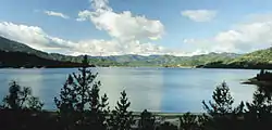 Whiskeytown Lake on Clear Creek | |
| Location | |
| Country | United States |
| State | California |
| Region | Shasta Trinity |
| Physical characteristics | |
| Source | Damnation Peak |
| • location | Trinity Mountains, Shasta-Trinity National Forest |
| • coordinates | 40°57′31″N 122°31′45″W[1] |
| • elevation | 5,080 ft (1,550 m) |
| Mouth | Sacramento River |
• location | Girvan |
• coordinates | 40°30′20″N 122°22′04″W[1] |
• elevation | 415 ft (126 m) |
| Length | 60.6 mi (97.5 km)[2] |
| Basin size | 249 sq mi (640 km2)[3] |
| Discharge | |
| • location | French Gulch, above Whiskeytown Lake[4] |
| • average | 211 cu ft/s (6.0 m3/s)[5] |
| • minimum | 2.07 cu ft/s (0.059 m3/s) |
| • maximum | 14,600 cu ft/s (410 m3/s) |
| Basin features | |
| Tributaries | |
| • right | Crystal Creek, Brandy Creek |
Geography
The creek is 60.6 miles (97.5 km) long,[2] flowing in southern Siskiyou County and northern Shasta County. Clear Creek is the first major Sacramento River tributary downstream of the Shasta Dam.
Clear Creek originates in the Trinity Mountains, between Shasta Lake and Trinity Lake in the Shasta-Trinity National Forest, and flows into Whiskeytown Lake reservoir, impounded by Whiskeytown Dam. Past the reservoir, the stream bed continues south until its confluence with the Sacramento River. The Spring Creek Tunnel bypasses that section and delivers water from Whiskeytown Lake directly to Keswick Reservoir, both part of the Central Valley Project.
- History
The site along Clear Creek where Pierson B. Reading discovered gold in 1848 was declared a California Historical Landmark.[6]
References
- U.S. Geological Survey Geographic Names Information System: Clear Creek
- U.S. Geological Survey. National Hydrography Dataset high-resolution flowline data. The National Map Archived 2016-06-30 at the Wayback Machine, accessed March 10, 2011
- http://www.sacriver.org/aboutwatershed/roadmap/watersheds/westside/clear-creek-watershed
- http://nwis.waterdata.usgs.gov/nwis/monthly/?referred_module=sw&site_no=11371000&por_11371000_2=2209235,00060,2,1950-10,1993-09&format=html_table&date_format=YYYY-MM-DD&rdb_compression=file&submitted_form=parameter_selection_list
- http://nwis.waterdata.usgs.gov/nwis/monthly/?referred_module=sw&site_no=11371000&por_11371000_2=2209235,00060,2,1950-10,1993-09&format=html_table&date_format=YYYY-MM-DD&rdb_compression=file&submitted_form=parameter_selection_list
- "Clear Creek". Office of Historic Preservation, California State Parks. Retrieved 2012-10-14.