Cima della Fascia
The Cima della Fascia is a mountain of the Ligurian Alps located in Piedmont (NW Italy).
| Cima della Fascia | |
|---|---|
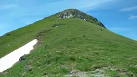
 The summit as seen from its N shoulder | |
| Highest point | |
| Elevation | 2,495 m (8,186 ft) [1] |
| Prominence | 276 m (906 ft) [2][1] |
| Coordinates | 44°16′12″N 7°36′21″E |
| Geography | |
 Cima della Fascia Location in the Alps | |
| Location | Piemonte, Italy |
| Parent range | Ligurian Alps |
| Climbing | |
| First ascent | ancestral |
| Easiest route | hiking |
Geography
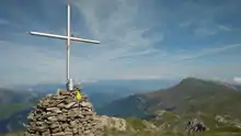
The mountain stands on the ridge dividing the valleys of Vermenagna and Pesio.[3] Southwards the water divide continues heading to the Bric Costa Rossa, while northwards in connects Cima della Fascia with the main chain of the Alps. The summit, which offers a very vast panorama, is marked by a cairn bearing a metallic summit cross; in the base of the cairn a box contains the summit register.
SOIUSA classification
According to the SOIUSA (International Standardized Mountain Subdivision of the Alps) the mountain can be classified in the following way:[4]
- main part = Western Alps
- major sector = South Western Alps
- section = Ligurian Alps
- subsection = It:Alpi del Marguareis/Fr:Alpes Liguriennes Occidentales
- supergroup = It:Catena Marguareis-Mongioie/Fr:Chaîne Marguareis-Mongioie
- group = It:Gruppo Testa Ciaudon-Cima della Fascia
- subgroup = It:Dorsale della Cima della Fascia
- code = I/A-1.II-B.3.b
Geology

The mountain stands in a karstic area. Its basement is mainly formed of Triassic limestone, the intermediate portion of younger limestone, of Jurassic origin, and the summit of layers of Eocenic schists.[5]
Conservation
The eastern slopes of the mountain, facing the Pesio Valley, are part of the Natural Park of Marguareis, a nature reserve established by Regione Piemonte.
Access to the summit

The Cima della Fascia can be reached hiking from Limone Piemonte.[6] The mountain is also accessible in winter by ski mountaineers, with quite a demanding itinerary.[7]
Maps
- Cartografia ufficiale italiana in scala 1:25.000 e 1:100.000 (Map). Istituto Geografico Militare.
- Carta in scala 1:50.000 n. 8 Alpi Marittime e Liguri (Map). Torino: Istituto Geografico Centrale.
References
- 1:25.000 map nr.16 "Val Vermenagna Valle Pesio Alta val Ellero Parco naturale del Marguareis" (Map). Ciriè: Fraternali.
- Key col: Colla Bassa di Malaberga (2.219 m)
- Carta in scala 1:50.000 n. 8 Alpi Marittime e Liguri (Map). Torino: Istituto Geografico Centrale.
- Marazzi, Sergio (2005). Atlante Orografico delle Alpi. SOIUSA (in Italian). Priuli & Verlucca. p. 64. ISBN 978-88-8068-273-8.
- Memorie della Società geologica italiana (in Italian). 2. Industria Tipografica Romana. 1939. p. 247. Retrieved 2019-07-20.
- "Tetti Barat (Limone) - Capanna Chiara - Vallone del Cros - Cima della Fascia" (in Italian). L'appenninista. September 2017. Retrieved 2019-07-20.
- "Scheda tecnica - Cima della Fascia da Limone Piemonte" (PDF) (in Italian). cuneoclimbing. Retrieved 2019-07-20.
![]() Media related to Cima della Fascia at Wikimedia Commons
Media related to Cima della Fascia at Wikimedia Commons