Chopta Bugyal
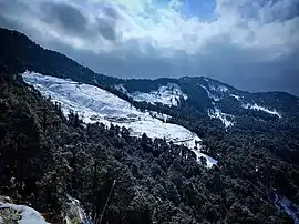
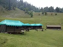
"Chopta Bugyal" , also known as "Tungnath Bugyal" or "Rohini Bugyal" is a cluster of Bugyals (Himalayan Alpine Meadows) in Chopta, Rudraprayag district of Uttarakhand. Chopta Bugyal is a popular Trekking and Camping Destination. The Bugyal has an average elevation of 2849m and is around 30 km from Ukhimath. It is situated on the Trek route to Tungnath, the third temple of the Panch Kedar and the highest Shiva temple in the world and Chandrashila, a summit at an altitude of 3645m.[1] Chopta Bugyal is surrounded by forests of pine, deodar and rhododendron and is rich in flora and fauna.
| Chopta Bugyal | |
|---|---|
 Chopta Bugyal | |
| Highest point | |
| Elevation | 2,849 m (9,347 ft) |
| Coordinates | 30.4885834°N 79.1997910°E |
| Geography | |
| Location | Rudraprayag, Uttarakhand, India |
| Parent range | Garhwal Himalaya |
Chopta is also a popular destination during the winter as well as summer months due to the climatic conditions that the area experiences. Chopta Bugyal remains covered with red carpet Rhododendron flowers during the months of March and April. The spectacular views of Garhwal Himalayas including Nanda Devi and Chaukhamba can be seen from Chopta Bugyal.[2] Tungnath, located just three and a half kms from Chopta and Chandrashila peak, located about five kms from Chopta are a must visit. Also Deoria Tal, a freshwater lake which is around 20 km from here is another place to visit.
Gallery
References
- "Rohini Bugyal Trek". trekiking.com.
- "Rohini Bugyal". euttaranchal.com.