Cedar Lake East Beach
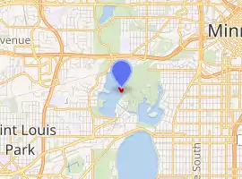
Cedar Lake East Beach is an urban beach in Minneapolis, Minnesota, United States. It is managed by the Minneapolis Park and Recreation Board and located on the east side of Cedar Lake. Formerly known as Hidden Beach, the area used to be obscured down a forested path, which contributed to its rise of prominence in the 1960s and 1970s as enclave of counter-culture.[1] After receiving attention for several decades due to illicit activities and safety concerns, the beach underwent a contentious "family-friendly" shift following efforts by the park board in the late 2010s. [2]
| Cedar Lake East Beach | |
|---|---|
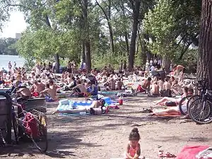 Many people at Cedar Lake Beach, then known as Hidden Beach, in July 2007. | |
| |
| Type | Swimming beach |
| Location | Minneapolis, Minnesota, United States |
| Operated by | Minneapolis Park and Recreation Board |
| Open | Daily, 6:00 a.m. to 10:00 p.m. |
| Designation | Life guards on duty seasonally |
| Website | Cedar Lake East Beach |
History
Railway: 1860s to 1980s
Before 1867, Cedar Lake had a much different shape, and most of the woods surrounding Cedar Lake East Beach, particularly to the south east, were areas of water and wetland. In 1867, the St. Paul and Pacific Railway (a precursor to the BNSF Railway) built an earthen causeway through what was then a large bay on the east side of Cedar Lake. In 1871, the Minneapolis and St. Louis Railroad joined the St. Paul and Pacific Railway, running parallel tracks along the causeway. Slowly, by dumping cinders and other material, the part of the bay east of the causeway was filled in. The Minneapolis and St. Louis Railroad (became the St. Paul, Minneapolis, and Manitoba and moved its tracks from the east side to the north side of the lake 1883) then used the new land to create a major train yard. In 1878, a large scale ice cutting operation known as Cedar Lake Ice Company was founded on the lake’s north eastern shore, which shipped ice to places as far away as St. Louis, Missouri. By 1900, Dingley’s boat house occupied the end of a thin peninsula on the eastern side of the lake, which eventually widened and became the site of Cedar Lake East Beach.
In 1913, as part of the effort to create the Chain of Lakes as well as the Grand Rounds Scenic Byway, Cedar Lake was lowered by 5 feet (1.5 m) to connect it with Lake of the Isles. As a result, what remained of the East Bay (west of the old earthen rail corridor) completely dried up. Despite the large railway operations going on nearby, the land surrounding Cedar Lake’s eastern shore was sold to build houses, hotels, and other such structures between 1895 and 1975. Unlike today, houses occupied both sides of Upton Avenue South. In the 1950s, the area was used as a city dump. Much of the road construction debris from the interstate highway projects wound up as mounds of rubbish along the eastern shoreline of Cedar Lake. The area quickly overgrew with cottonwood trees, resulting in the forested hills to the southeast of the beach.
Counter-culture: 1960s to 1990s
Sometime in the 1960s, the beach came to prominence. At the time, the beach was only a small grassy clearing by the shore, led to by a deer path-sized trail. It became known locally as an unofficial nude beach. Most of the railway yard closed by the mid-1980s, and the tracks and buildings were removed. In 1988, residents in the surrounding neighborhood purchased the land to the west of Upton Avenue South, between the lake and the road, and turned it into a city park with a vision of establishing a nature park.
Park conversion: 1990s to 2010s
In 1995, residents in the neighborhood surrounding the beach used money from the Neighborhood Revitalization Plan funds to hire off-duty police officers to patrol the beach more frequently. This was done officially through the Kenwood Isles Area Association. The reasons behind this stemmed from a concern over illegal activity at the beach. Residents claimed that they were concerned with their safety and wanted to crack down on nudity, drug use, parties, and crime. Some believed that a lack of an official entrance to the beach represented a major obstacle for the park police to patrol and gain access freely. Some patrons of the beach claimed that the wealthy residents in the surrounding neighborhood wanted to reduce or eliminate use by non-residents. The police reported that crime was not any higher at the beach than it was at many other official beaches in Minneapolis. The Kenwood Isles Area Association pushed the Minneapolis Park and Recreation Board for a solution. Yet, others were concerned over the pervasiveness of an invasive species of Buckthorn which had grown over 70% of the park. In 2002, the park board decided to renovate the park due to both the safety and ecologic concerns. That summer, the park board widened paths leading to the beach by clearing buckthorn, as well as non-invasive trees. The park board removed additional vegetation in subsequent years.
In 2007, community members held a session of meetings to address the growing concern over activity at the beach. Neighbors voted down a proposal to build a large parking lot. However, they voted in favor of graveling the path to the beach, which required removal of additional trees, to allow for service and police vehicles to reach the beach area. Other renovations approved included installation of picnic tables, a grill, and a lifeguard stand. The initial wood life guard stand burned down, which some suspect was deliberate by vandals, and was replaced with a metal stand.
In popular culture
The cover for the 1985 album New Day Rising by Hüsker Dü was shot at Hidden Beach.[3]
Photo gallery
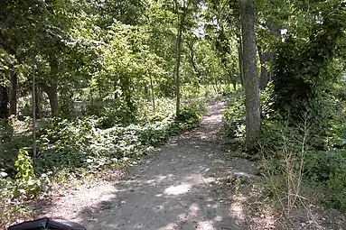 South eastern portion of Cedar Lake East Beach in August 2005.
 Mud pit area in 2006.
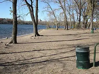 View of Cedar Lake East Beach in the late fall of 2006.
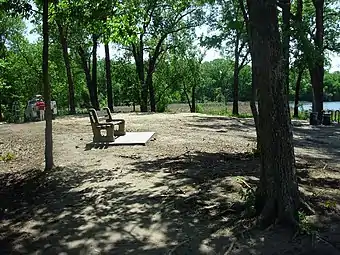 Forest canopy above the nature beach surface with a concrete bench.
 A destroyed life guard tower at Cedar Lake East Beach in 2017.
See also
References
- Snyders, Matt (June 25, 2008). "The Legend of Hidden Beach". City Pages.
- Zamora, Karen (June 19, 2018). "Choppy waters at Cedar Lake's Hidden Beach". Star Tribune.
- Matos, Michaelangelo (2017-09-25). "Review: Hüsker Dü, 'Savage Young Dü'". North Country Public Radio. Canton, New York. Retrieved 2020-11-18.
External links
| Wikimedia Commons has media related to Cedar Lake East Beach. |