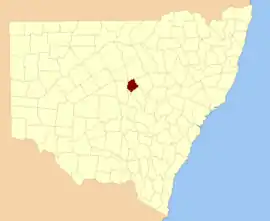
Carual, New South Wales
Carual, New South Wales also known as Carval is a civil parish and rural locality of New South Wales located at 31°37'54.0"S 147°44'04.0"E.
| Carual Parish New South Wales | |||||||||
|---|---|---|---|---|---|---|---|---|---|
 | |||||||||
 Carual Parish | |||||||||
| Coordinates | 31°42′S 147°50′E | ||||||||
| Postcode(s) | 2824 | ||||||||
| Elevation | 198 m (650 ft) | ||||||||
| LGA(s) | Warren Shire | ||||||||
| State electorate(s) | Barwon | ||||||||
| Federal Division(s) | Parkes | ||||||||
| |||||||||
Carual Parish (Oxley County), New South Wales is a rural locality of Warren Shire and a civil parish of Oxley County, New South Wales,[1] a Cadastral divisions of New South Wales.[2]
Geography
The parish is on Crooked Creek and also on the Macquarie River east of Nyngan,[3] and outside of Warren, New South Wales. The economy of the parish is based on broad acre agriculture, mainly sheep, cattle and wheat. The topography is flat with a Köppen climate classification of BsK (Hot semi arid).[4]
The economy in the parish is based on broad acre agriculture, based on Wheat, sheep and cattle.
The traditional owners of the area are the Wiradjuri[5][6] people.
History
Before European settlement the area is said to have been occupied by the Ngiyambaa Aborigines. Some say the name Warren derives from a local Aboriginal word, meaning "strong" or "substantial".
Explorer John Oxley camped on the present of Warren during his investigation of the Macquarie River in 1818. He noted an abundance of kangaroos and emus.
Charles Sturt carried out further exploration in 1828–29.
Cattle were grazing in the area by the late 1830s.[7] Warren station was established in 1845 by Thomas Readford and William Lawson, the son of explorer William Lawson who was a member of the first European party to breach the Blue Mountains in 1813.
The railway arrived in 1898 and Burrendong Dam was opened in 1967, allowing the development of cotton and produce.
References
- Robert McLean, The New atlas of Australia : the complete work containing over one hundred maps and full descriptive geography of New South Wales, Victoria, Queensland, South Australia and Western Australia, together with numerous illustrations and copious indices (Sydney :John Sands, [1886) Map 14.
- "Oxley County". Geographical Names Register (GNR) of NSW. Geographical Names Board of New South Wales.

- County of Oxley, New South Wales. Department of Lands 1922.
- Peel, M. C.; Finlayson, B. L.; McMahon, T. A. (2007). "Updated world map of the Köppen–Geiger climate classification". Hydrol. Earth Syst. Sci. 11: 1633–1644. doi:10.5194/hess-11-1633-2007. ISSN 1027-5606. (direct: Final Revised Paper)
- Norman Tindale's Catalogue of Australian Aboriginal Tribes
- Aboriginal Australia Map, David Horton (ed.), 1994 published in The Encyclopedia of Aboriginal Australia by AIATSIS.
- "Warren - New South Wales - Australia - Travel - smh.com.au". www.smh.com.au. Retrieved 29 March 2016.