Cape Londonderry
Cape Londonderry is the northernmost point of mainland Western Australia, as well as the southwestern corner of the Timor Sea.[1] It lies east of Cape Talbot and northeast of Kalumburu (the nearest settlement), in Western Australia's Kimberley region.
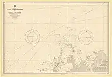
The Cape Londonderry region on a nautical chart
The cape was surveyed by Philip Parker King in 1818 and named after the Marquess of Londonderry, Britain's then Foreign Secretary.[2] Plans to build an airstrip and fishing base there were approved by Western Australia's Environmental Protection Authority in 1992, but are yet to go ahead.[3]
Notes
- "Limits of Oceans and Seas, 3rd edition" (PDF). International Hydrographic Organization. 1953. p. 28. Archived from the original (PDF) on 8 October 2011. Retrieved 29 December 2020.
- "Cape Londonderry, Western Australia" (PDF). Foyle Civic Trust.
- "Airstrip and fishing base, Cape Londonderry". Environmental Protection Authority of Western Australia.
This article is issued from Wikipedia. The text is licensed under Creative Commons - Attribution - Sharealike. Additional terms may apply for the media files.