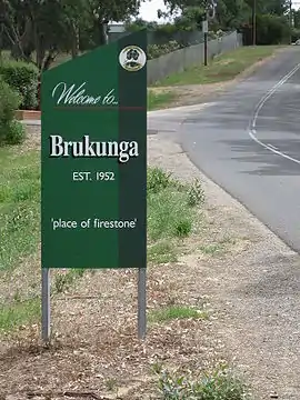
Brukunga
Brukunga is a small town in the Adelaide Hills, located approximately 40 kilometres (25 mi) east of Adelaide and 4 kilometres (2.5 mi) north of the town of Nairne.
| Brukunga South Australia | |
|---|---|
 Western entrance to Brukunga | |
 Brukunga | |
| Coordinates | 35°00′0″S 138°57′0″E |
| Population | 433 (2016 census)[1] |
| Established | 1952 |
| Postcode(s) | 5252 |
| Location | |
| LGA(s) | District Council of Mount Barker |
| State electorate(s) | Kavel |
| Federal Division(s) | Mayo |
History
Its name, derived from Barrukungga in the local Kaurna language, means "place of fire stone"[2] or the "place of hidden fire", and is associated with the creator ancestor of the Kaurna people, Tjilbruke. Tjilbruke's body was said to have been transformed into the outcrop of iron pyrite at Barrukungga.[3] However the etymology is complex and uncertain. While Brukunga is on Peramangk traditional land, the word Barrukungga has both Kaurna and Ngarrindjeri language elements. Norman Tindale noted that "The natives were well aware of the use of iron pyrites along with flint for the striking of fire and the area near Nairne was one of the places from which they obtained supplies of iron pyrites".[4]
Between 1955 and 31 May 1972, iron sulphides (mainly as pyrite) was mined at the Nairne Pyrite Mine—later renamed as the Brukunga Mine—immediately west of the town, and transported to Port Adelaide for the production of sulphuric acid, used for manufacturing superphosphate fertiliser.[5] Oxidation of pyrite in waste dumps and the exposed quarry face led to formation of acid mine drainage containing high levels of cadmium and other heavy metals into the adjacent creek, triggering health warnings by the Environment Protection Agency in 1998.[6] Since 1980, rehabilitation of the mine site has occurred, including a lime neutralisation plant to treat acid water before it enters the Dawesley Creek,[7] but concerns over water quality remain.[8] Revegetation of the site has also progressively occurred since 1988.
Description
At the 2016 Australian census, Brukunga had a population of 433.[1]
The town is the location of the Country Fire Service training centre and the Claremont Airbase which has been the main operating base for aerial firefighting since 2016.[9]
References
- Australian Bureau of Statistics (27 June 2017). "Brukunga (State Suburb)". 2016 Census QuickStats. Retrieved 19 November 2020.

- SA State Gazetteer > Placenames online Archived 10 January 2014 at the Wayback Machine Site is a searchable database. Accessed 17 April 2012.
- "Arts and culture". City of Marion. 7 February 2018. Retrieved 19 November 2020.
- Schultz, Chester (22 October 2018). "Place Name Summary 6/23: Brukangga and Tindale's uses of the word bruki" (PDF). Adelaide Research & Scholarship. University of Adelaide. Retrieved 16 November 2020.
- Armstrong, D. & Cox, R. (2005): The Brukunga Pyrite Mine –South Australia A Review of Developments since Closure in 1972 9th International Mine Water Congress Oviedo, Asturias, Spain. 5–7 September 2005, pp 201-207 Accessed 6 December 2011.
- Keane, A. (1998): Health warnings over Hills creek water. The Advertiser, 1 August 1998.
- "Brukunga Mine Site". DMITRE Minerals >...> Former Mines > Brukunga mine site. 13 November 2009. Retrieved 6 December 2011.
- Milnes, M. (2012): Mine to stay toxic for years The Advertiser, 7 March 2012. Accessed 17 April 2012.
- "Adelaide Hills gets new CFS air base at Brukunga to support firefighting". ABC News. 11 December 2016. Retrieved 20 November 2020.