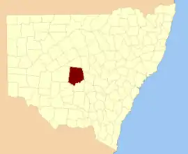
Blaxland County

Blaxland County is one of the 141 Cadastral divisions of New South Wales. It is bounded to the south by the Lachlan River and a small part of Waverley Creek. It includes Mount Hope and the Nombinnie Nature Reserve.

Blaxland
New South Wales
Location in New South Wales
Lands administrative divisions around Blaxland:
Mouramba Mouramba Flinders
Mossgiel Blaxland Cunningham
Franklin Dowling Gipps

Blaxland County was named in honour of John Blaxland, landowner and merchant.[1]

Parishes within this county

A full list of parishes found within this county; their current LGA and mapping coordinates to the approximate centre of each location is as follows:

ParishLGACoordinates
Back RotoCarrathool Shire33°07′59″S 145°33′45″E
Back WallandraCarrathool Shire33°08′14″S 145°42′33″E
Back WhoeyCobar Shire33°06′42″S 146°12′06″E
BeauportCobar Shire32°53′22″S 146°35′59″E
BogaloCobar Shire32°42′10″S 146°14′02″E
Bogalo SouthCobar Shire32°46′37″S 146°13′38″E
BooberoiCobar Shire33°03′34″S 146°31′00″E
BoothumbleCobar Shire32°55′46″S 146°13′04″E
BuckleyCarrathool Shire33°18′51″S 145°44′41″E
BundureCobar Shire32°39′56″S 146°04′56″E
Bundure SouthCobar Shire32°44′10″S 146°04′14″E
BurthongCobar Shire32°24′53″S 146°17′54″E
Burthong SouthCobar Shire32°30′37″S 146°15′36″E
CagellicoCobar Shire33°00′17″S 146°16′13″E
CalytriaCobar Shireunknown
CoanCobar Shire32°45′21″S 145°43′40″E
CobramCobar Shire32°32′08″S 146°03′26″E
CoreeCobar Shire32°40′28″S 145°56′04″E
Creamy HillsCobar Shire32°58′57″S 146°28′15″E
CurrawallahCobar Shire32°40′36″S 146°24′17″E
East GilgunniaCobar Shire32°27′59″S 145°57′44″E
EeramaranCobar Shire32°28′54″S 146°21′04″E
EribenderyCobar Shire33°07′45″S 146°21′18″E
EuabalongCobar Shire33°05′09″S 146°25′10″E
GilgunniaCobar Shireunknown
GonnCobar Shire32°52′17″S 145°44′29″E
GooanCobar Shire32°30′04″S 145°56′50″E
GounelgerieCarrathool Shire32°58′00″S 145°31′58″E
GuagongCobar Shireunknown
GuapaCobar Shire32°33′24″S 146°13′37″E
Guapa WestCobar Shire32°37′25″S 146°07′45″E
GunnagiCarrathool Shire33°11′08″S 145°28′56″E
HyandraCobar Shire33°10′36″S 146°12′04″E
IllewongCobar Shire32°53′01″S 146°20′15″E
Illewong WestCobar Shire32°53′27″S 146°12′36″E
InaCobar Shire33°01′43″S 146°02′55″E
JundrieCarrathool Shire33°19′34″S 146°00′07″E
KeginniCobar Shire32°36′10″S 145°39′04″E
KilleenCobar Shire32°29′37″S 145°47′28″E
Killeen SouthCobar Shire32°33′18″S 145°46′14″E
MahurangiCobar Shire33°02′44″S 145°40′46″E
Mahurangi EastCobar Shire33°02′52″S 145°46′01″E
ManopaCarrathool Shire33°00′24″S 145°35′50″E
MarobeeCobar Shire32°33′51″S 146°25′27″E
Marobee EastCobar Shire32°36′43″S 146°32′07″E
MaroobaCarrathool Shire32°51′39″S 145°37′11″E
MatakanaCobar Shire32°57′34″S 145°53′25″E
Matakana SouthCobar Shire33°04′09″S 145°53′25″E
MeldiorCobar Shire32°51′43″S 146°28′46″E
MelleleaCobar Shire33°02′25″S 146°10′56″E
MerrimerriwaCobar Shire32°43′23″S 145°35′52″E
MooraCobar Shire32°58′58″S 146°21′44″E
MordieCarrathool Shire32°54′58″S 145°31′44″E
Mount AllenCobar Shire32°44′02″S 145°52′49″E
Mount HopeCobar Shire32°53′33″S 145°51′40″E
Mount SolitaryCobar Shire32°54′23″S 145°56′45″E
MulgaCobar Shire32°59′00″S 146°02′34″E
NombinnieCobar Shire32°47′28″S 145°46′49″E
North HyandraCarrathool Shire33°13′44″S 146°00′35″E
North PeakCobar Shire32°27′21″S 146°09′26″E
OneidaCarrathool Shire33°05′54″S 145°51′31″E
RotoCarrathool Shire33°10′25″S 145°34′26″E
SalamagundiaCarrathool Shire33°09′43″S 145°54′32″E
South PeakCobar Shire32°24′04″S 145°59′48″E
South ThuleCobar Shire32°24′10″S 145°42′27″E
South YackerboonCobar Shire32°24′51″S 145°49′47″E
TallebungCobar Shire32°40′06″S 146°32′18″E
TaraCobar Shire32°35′18″S 146°18′31″E
Tara SouthCobar Shire32°37′39″S 146°18′10″E
TarcombeCobar Shire32°23′41″S 146°05′54″E
TarranCobar Shire32°27′08″S 146°28′00″E
ThuleCobar Shire32°20′44″S 145°42′57″E
TorcobilCarrathool Shire33°15′10″S 145°47′00″E
UlaluCarrathool Shire33°08′40″S 146°02′14″E
UlambongCobar Shireunknown
UlumbaCarrathool Shire32°48′20″S 145°35′05″E
UrambieCobar Shire32°46′30″S 146°27′27″E
Urambie EastCobar Shire32°45′30″S 146°34′15″E
UranawayCarrathool Shire33°18′10″S 145°53′18″E
VictorCobar Shire32°38′38″S 145°49′44″E
WaggaCobar Shire32°37′44″S 145°45′21″E
Walla WollongCobar Shire32°49′10″S 146°22′03″E
WallandraCarrathool Shire33°11′19″S 145°40′32″E
WarbreccanCobar Shire32°24′36″S 145°34′43″E
WarrabillongCobar Shire32°48′50″S 146°32′08″E
West UabbaCarrathool Shire33°15′30″S 146°00′03″E
WhoeyCobar Shire33°10′35″S 146°18′15″E
WilgaCarrathool Shire33°12′28″S 145°47′35″E
YackerboonCobar Shire32°23′14″S 145°48′18″E
YaraCobar Shire32°49′44″S 146°02′25″E
Yara EastCobar Shire32°54′53″S 146°06′17″E
YathongCobar Shireunknown

References

  1. "Blaxland County". Geographical Names Register (GNR) of NSW. Geographical Names Board of New South Wales.
This article is issued from Wikipedia. The text is licensed under Creative Commons - Attribution - Sharealike. Additional terms may apply for the media files.