Bhood
Bhood is a village in Khanapur tehsil of Sangli district in Maharashtra, India.[3][4] It is located near the city Vita.[5]
Bhood | |
|---|---|
Village | |
 Bhood  Bhood | |
| Coordinates: 17°20′11″N 74°41′3″E | |
| Country | India |
| State | Maharashtra |
| District | Sangli |
| Taluka | Khanapur (Vita) |
| Government | |
| • Type | Grampanchayat[1] |
| Area | |
| • Total | 15.16 km2 (5.85 sq mi) |
| Elevation | 785 m (2,575 ft) |
| Population (2011) | |
| • Total | 1,889 |
| • Density | 120/km2 (320/sq mi) |
| • Literacy | 76.62% |
| Sex ratio | |
| • 1104/1000 | Female/Male |
| Language | |
| • Official | Marathi |
| Time zone | UTC+5:30 (IST) |
| PIN | 415309 [2] |
| STD Code | +91-2347 |
| Vehicle registration | MH-10 (Sangli) |
| Website | www.bhood.in |
The population of Bhood is 1,889 according to the 2011 Census,[6] with agriculture being the prime occupation of the village's residents. Some residents are also employed at a Gold Refinery and the Jewellery business. Bhood is recipient of the Nirmal Gram Purskar in Sant Gadage Baba Gram Swachata Abhiyan.[7][8]
Climate
| Bhood | ||||||||||||||||||||||||||||||||||||||||||||||||||||||||||||
|---|---|---|---|---|---|---|---|---|---|---|---|---|---|---|---|---|---|---|---|---|---|---|---|---|---|---|---|---|---|---|---|---|---|---|---|---|---|---|---|---|---|---|---|---|---|---|---|---|---|---|---|---|---|---|---|---|---|---|---|---|
| Climate chart (explanation) | ||||||||||||||||||||||||||||||||||||||||||||||||||||||||||||
| ||||||||||||||||||||||||||||||||||||||||||||||||||||||||||||
| ||||||||||||||||||||||||||||||||||||||||||||||||||||||||||||
The village has a semi arid, hot and dry climate consisting of mainly three seasons. Summers are long, ranging almost five months from mid February to June. Temperatures in summer fall between 35 °C (95 °F) - 40 °C (104 °F). However, it may reach higher than 40 °C in searching summer. May is the hottest month of a year with an average day temperature of 37 °C (98.6 °F) in the village. Winters are short with temperatures ranging within 15 °C (59 °F) - 21 °C (69.8 °F). December is the coldest month in a year. Relative humidity in winter is the lowest and December is the driest month in a year with the relative humidity as low as 30%. Rains are scarce and occur only during the Monsoon from mid June to September. Annual average rainfall is about 25.5 inches (647.7 mm). September gets the maximum rainfall in a year while July has the maximum rainy days.
| Climate data for Bhood | |||||||||||||
|---|---|---|---|---|---|---|---|---|---|---|---|---|---|
| Month | Jan | Feb | Mar | Apr | May | Jun | Jul | Aug | Sep | Oct | Nov | Dec | Year |
| Average high °C (°F) | 31 (88) |
33 (91) |
36 (97) |
38 (100) |
37 (99) |
31 (88) |
28 (82) |
28 (82) |
30 (86) |
32 (90) |
30 (86) |
30 (86) |
32 (90) |
| Average low °C (°F) | 12 (54) |
15 (59) |
18 (64) |
21 (70) |
22 (72) |
22 (72) |
21 (70) |
21 (70) |
20 (68) |
19 (66) |
16 (61) |
13 (55) |
18 (65) |
| Average precipitation mm (inches) | 3.8 (0.15) |
0.5 (0.02) |
5.3 (0.21) |
22.1 (0.87) |
48.3 (1.90) |
71.1 (2.80) |
108.7 (4.28) |
79.8 (3.14) |
99.6 (3.92) |
88.9 (3.50) |
33.5 (1.32) |
6.9 (0.27) |
568.5 (22.38) |
| Source: Government of Maharashtra | |||||||||||||
Location
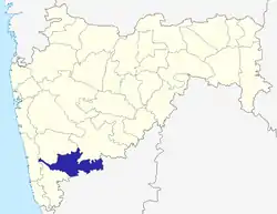
Bhood is located in south-western Maharashtra at 17°20′11″N 74°41′3″E in Khanapur (Vita) tehsil of the Sangli district.
Government and politics
Local administration
The Grampanchayat Bhood is the administrative body for the village which is directly responsible for the affairs within the village. The village has been divided into 3 Wards, each ward has its 3 elected representatives called 'Gramsadasy' or 'punch'. The gramsadasy elect the 'Sirpunch' of the Grampanchayat which is head of the Grampanchayat. The Grampanchayat elections are held after every five years. The Grampanchayat Bhood is working with Zilla Parishad, Sangli and Panchayat samiti, Vita. Bhood is under the Lengare division for Zilla parishad, Sangli and Panchayat samiti, Vita.
State and central administration
Bhood is under the Pune division. Pune division is one of the six administrative divisions of Maharashtra state in India. Bhood is under the Sangli Lok Sabha constituency and Khanapur-Atpadi Vidhan Sabha constituency. MDDS e-Governance code for Bhood is 27 531 04299 568523.[9]
Judiciary
Bhood is under the jurisdictional area of Bombay High Court. District level court is in Sangli (Sangli district court). And tehsil level court is in Vita. The village is under the working area of Vita police station.
Transportation
Road
Bhood is connected by road to the nearest village Lengare located at a distance of (5 km) by the Bhood-Lengare road which further connects to the Vita city. Bhood is at a distance of 275 km south-west of Mumbai, 73 km north of Sangli and 18 km from Vita. The nearest villages and towns are Khanapur (10 km), Lengare, and Kharsundi (13 km). Bhood has bus stand served by the buses of Maharashtra State Road Transport Corporation.
Railway
Nearest railway station is Karad (55 km). Miraj railway junction is 65 km from Bhood. Trains to all major cities in India are available from Karad and Miraj railway stations.
Air
Nearest domestic airport from Bhood is Kolhapur (90 km). Kolhapur airport located at Ujalaiwadi, 9 km South-east from the Kolhapur city. Its sole regular service to Mumbai by Kingfisher Airlines ceased in November 2011 when the airline pulled out of several towns like Kolhapur due to its financial crisis.[10] Pune Airport located at a distance of 175 km by road from Bhood is the nearest functional airport. It has regular service to all major cities in India.
Demographics
| Population Growth | |||
|---|---|---|---|
| Census | Population | %± | |
| 1991 | 1,395 | — | |
| 2001 | 1,889 | 35.4% | |
| 2011 | 1,889 | 0.0% | |
| Source: Census of India | |||
Bhood has a population of 1,889. With the male population at 898 and the female at 991. There are 1,104 females per 1,000 males in the village amongst 455 households.[6] People of various ethnic groups live in Bhood.
The census code for Bhood is 04328200[11] and its village code according to 2011 Census is 27 35 005 0025.[12]
Because of its gold-refinery and jewellery business many people of Bhood are today spread throughout India. According to 1991 Census, the population of Bhood was 1395.[13]
Places of worship
There are number of temples in Bhood. Some of them are...
Education
Schools
- Zila Parishad School provides primary education from class 1 to class 7. The school is governed by the Zilla Parishad of Sangli with the help of the local Panchayat samiti of Vita and the Gram panchayat of Bhood. The school is located near S.T. Stand of Bhood and is equipped with educational facilities.
- New English School provides secondary education from class 8 up to class 10 (matriculation level). The school is affiliated to the S.S.C. Board. It is situated near the Bhood-Khanapur road.
Colleges
Higher education is available in the colleges in the following localities of Bhood:
- Vita, located at the distance of 18 kilometres (11 mi) from Bhood
- Khanapur, Located 10 kilometres (6.2 mi) away from Bhood
Gallery

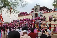
 Bhoodsidhhanath temple
 Bullock cart race in Bhood
See also
References
- "List of Census Villages mapped for :BHOOD Gram Panchayat,KHANAPUR-VITA,SANGLI,MAHARASHTRA". Ministry of Panchayati Raj Government of India. Retrieved 26 August 2012.
- "Postal Code". Indian Post.
- Alphabetical list of villages. India. Directorate of Census Operations, Maharashtra. 2010. p. 1726.
- "DIRECTORY OF VILLAGES AND TOWNS". Sangali District Gazetteer. Government of Maharashtra. Retrieved 19 September 2013.
- "censusindia.gov.in/Census_Data_2001/Village_Directory". Census_Data_2001. Government of India. Archived from the original on 10 March 2016. Retrieved 18 July 2012.
- "Census data 2011". Census_Data_2011. Government of India. Archived from the original on 4 May 2013. Retrieved 18 July 2012.
- "NGP 2009". Ministry of Drinking Water & Sanitation, Government of India. Archived from the original on 11 May 2012. Retrieved 25 July 2012.
- "Grampanchayat Bhood in Nirmal Bharat Abhiyan". Archived from the original on 22 August 2013. Retrieved 22 August 2013.
- List of MDDS e-Governance codes of villages in Maharashtra
- "Kingfisher suspends Kolkata flights". Business Standard. 18 February 2012. Retrieved 3 June 2012.
- Census code list for villages in Maharashtra., Census code for Bhood from Census 2001.
- Village code list for Maharashtra according to 2011 Census.
- India. Director of Census Operations, Maharashtra (1995). Volume 20 of Census of India, 1991. Controller of Publications. pp. 94, 181, 266. Retrieved 4 August 2012.
External links
| Wikimedia Commons has media related to Bhood. |
- BHOOD (Gram Panchayat) Portal by Department of Panchayati Raj Government of Maharashtra
- Information about Bhood from gloriousindia.com
- Village profile from indiastudychannel.com

