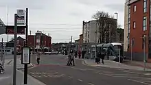
Beeston transport interchange
The Beeston transport interchange is an interchange between the trams of the Nottingham Express Transit (NET) network and local buses. It is situated in the centre of the town of Beeston in Nottinghamshire, England. The interchange is some 750 metres (0.5 mi) north-west of Beeston railway station.[1][2]
Beeston transport interchange | |||||||||||
|---|---|---|---|---|---|---|---|---|---|---|---|
| NET tram and bus interchange | |||||||||||
.jpg.webp) The transport interchange; the city-bound tram track is to the right, the outbound track is to the left of the leftmost bus | |||||||||||
| Coordinates | 52.925225°N 1.214703°W | ||||||||||
| Owned by | Nottingham Express Transit | ||||||||||
| Line(s) | NET Line 1 | ||||||||||
| Platforms | 2 island platforms, each with 1 tram stop and 3 bus stops | ||||||||||
| Tracks | 2 | ||||||||||
| Construction | |||||||||||
| Structure type | At grade; in street | ||||||||||
| Disabled access | Yes | ||||||||||
| History | |||||||||||
| Opened | 12 July 2015 (bus) 25 August 2015 (tram) | ||||||||||
| Services | |||||||||||
| |||||||||||

The interchange is modelled on a successful design used on the Strasbourg tram system in France, and comprises two staggered island platforms. Trams serve the outer faces of the platforms, using their off-side doors, whilst the inner faces are served by local bus services. An elongated facing crossover allows outbound trams to terminate in the inbound platform. Vehicular access to the interchange is restricted to buses and trams.[2][3][4]
The interchange opened to buses 12 July 2015 and has replaced the previous Beeston bus station, which was situated nearby. The tram stop within the interchange opened on 25 August 2015, along with the rest of NET's phase two.[1][3][4][5]
Tram services
The stop is on line 1 of the NET, from Hucknall via Nottingham city centre to Beeston and on to Chilwell, and is shown as Beeston Town Centre on NET publicity. Trams run at frequencies that vary between 4 and 8 trams per hour, depending on the day and time of day.[1][2]
Bus services
The interchange is served by the following bus routes:[4][6]
- 18 : Stapleford - Beeston - Rylands - Nottingham
- 20 : Heanor - Marlpool - Shipley - Ilkeston - Larklands - Kirk Hallam - Trowell - Stapleford - Bramcote - Beeston - Beeston Rylands - QMC - Nottingham
- 36 : Chilwell - Beeston - Queen's Medical Centre - Nottingham
- 510 : Beeston - Toton - Stapleford
- 536 : Beeston - Bramcote Avenue
- indigo : Derby - Long Eaton - Beeston - Queen's Medical Centre - Nottingham
- L10 : Beeston - Wollaton - Nottingham
- L11 : Beeston - Bulwell
- N34 : Beeston - Nottingham
- N36 : Nottingham - Beeston - Chilwell
- Y5 : Derby - Long Eaton - Beeston - Nottingham
References
- "Extending your Tram Service" (PDF). Nottingham Express Transit. Archived (PDF) from the original on 7 August 2015. Retrieved 5 August 2015.
- Skelsey, Geoffrey (2015). Nottingham's growing tramway - Building on NET's success. LRTA. pp. 70–74. ISBN 978-0-948106-49-1.
- "New station set to open in Beeston". Nottingham Post. Local World. 7 July 2015. Archived from the original on 8 July 2015. Retrieved 8 September 2015.
- Your new Beeston Bus and Tram Interchange - leaflet. Nottinghamshire County Council. 29 July 2015. Retrieved 9 September 2015.
- "Nottingham Express Transit Phase 2 opens". Railway Gazette. DVV Media UK Ltd. 25 August 2015. Archived from the original on 28 August 2015. Retrieved 25 August 2015.
- "Beeston bus and tram interchange". Nottinghamshire County Council. Archived from the original on 3 March 2019. Retrieved 3 March 2019.