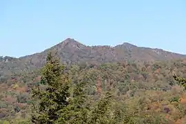
Bear's Paw
Hanging Rock, also known as Bear's Paw (Yonah‑wayah in Cherokee),[3] is a mountain in the North Carolina High Country, next to the town of Seven Devils. It is along the Avery and Watauga border. Its elevation reaches 5,203 feet (1,586 m). The mountain generates feeder streams for the Elk and Watauga rivers.
| Bear's Paw | |
|---|---|
| Hanging Rock | |
 Peak Mountain (left) and Bear's Paw (right) viewed from Grandfather Mountain | |
| Highest point | |
| Elevation | 5,203 ft (1,586 m) [1] |
| Prominence | 1,080 ft (330 m) [2] |
| Coordinates | 36°09′13″N 81°49′27″W [1] |
| Geography | |
 Bear's Paw Location in North Carolina | |
| Location | Avery / Watauga counties, North Carolina, U.S. |
| Parent range | Blue Ridge Mountains |
| Topo map | USGS Valle Crucis |
In 2008, Bear Paw State Natural Area was established on the mountain by the North Carolina General Assembly.[3] The High Country Conservancy acquired the initial 350 acres (1.4 km2) for the state,[4] and the park now encompasses 384 acres (1.55 km2).[5] The natural area is located just north of Grandfather Mountain State Park, and it protects Hanging Rock Ridge and the headwaters of Dutch Creek. It is managed by Grandfather Mountain State Park.
See also
References
- "Hanging Rock". Geographic Names Information System. United States Geological Survey. Retrieved 2009-12-29.
- "Hanging Rock". Peakbagger.com. Retrieved 2009-12-31.
-
"Session Law 2008-155". Raleigh, North Carolina: General Assembly of North Carolina. 2003-06-19. Retrieved 2011-09-13.
[T]his site was known by the Cherokee as Yonah‑wayah, or Bear's Paw[.]
- "Bear Paw and Yellow Mountain State Natural Areas Authorized". ncparks.gov. N.C. Department of Environment and Natural Resources. 2008-08-05. Retrieved 2011-09-13.
- "Size of the North Carolina State Parks System". North Carolina Division of Parks and Recreation. January 1, 2015. Archived from the original (XLS) on October 4, 2015. Retrieved September 2, 2015.
External links
- Bear Paw SNA Map by the Town of Seven Devils.