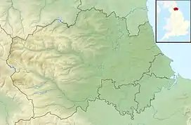
Balderhead Reservoir
Balderhead Reservoir is a reservoir in Baldersdale, County Durham, England. It is one of a chain of three reservoirs on the River Balder, a tributary of the River Tees, which it joins at Cotherstone, about 5 miles (8 km) to the east. Balderhead Reservoir was commissioned by the Tees Valley and Cleveland Water Board (TVCWB) to increase water supply to Teesdale and Teesside.
| Balderhead Reservoir | |
|---|---|
Aug2006.jpg.webp) | |
 Balderhead Reservoir | |
| Location | County Durham, England |
| Coordinates | 54°33′40″N 2°7′25″W |
| Type | Reservoir |
| Primary inflows | Moorland streams |
| Primary outflows | Blackton Reservoir |
| Catchment area | 5,140 acres (2,081 ha) |
| Managing agency | Northumbrian Water |
| Built | 1961 |
| First flooded | 1965 |
| Max. length | 1.77 mi (2.85 km) |
| Max. width | 0.56 mi (0.9 km) |
| Max. depth | 121 feet (37 m) |
| Water volume | 507,914,900 cubic feet (14,382,549 m3) |
| Surface elevation | 330 m (1,080 ft) |
| References | [1][2] |
History
In 1956, an upsurge in the chemical industry on Teesside led ICI to negotiate increased water supply from the Tees Valley Water Board. The first site considered, Cow Green, was above Cauldron Snout and was in a sensitive habitat area, so Balderhead was built instead.[3] The site was initially built as a direct supply route of water to Teesside, but later became a river-regulating reservoir, ensuring that water was available for the River Tees.[4] Cow Green Reservoir was built later, though the approval process was protracted due to the loss of habitat for the Teesdale violet plant.[5] Balderhead, which was originally in the North Riding of Yorkshire,[note 1] was approved for recreational activities by the Yorkshire Naturalists Union in the same year that it was opened, there being no objections on wildfowl grounds.[7]
Balderhead Reservoir was constructed upstream of two existing reservoirs, Blackton and Hury, and added 3,500 million imperial gallons (16,000,000 m3) to the storage capacity on the River Balder.[1] Construction of the Balderhead dam began in 1961 and was finished in 1964, with the reservoir being filled during 1965.[1] The dam, which was built of compacted boulder clay and shale, is 157 feet (48 m) high and 3,000 feet (910 m) long, and became, at completion, the highest earth dam constructed in the British Isles.[1]
When full, the reservoir can hold 507,914,900 cubic feet (14,382,549 m3) and has an overall perimeter length of 5 miles (8 km).[2] The catchment upstream of the reservoir is a mixture of rough grazing land and moorland which covers 12 miles (20 km).[8][9] The water quality is assessed as moderate for ecology and good for its chemical composition.[10]
Under the Water Act 1973, ownership of the TVCWB's reservoirs, which included the three Baldersdale reservoirs and two others — Selset and Grassholme — on the River Lune a short distance to the north, was transferred to the Northumbrian Water Authority (NWA).[11][12] In 1989, NWA was privatised, and the reservoirs are now owned and operated by Northumbrian Water.[13] All five reservoirs supply a water treatment works at Lartington, just south of Cotherstone.[14][15]
Recreationally, the reservoir is used by the Teesdale Sailing and Watersports Club for windsurfing, canoeing and kite surfing.[16]
See also
- List of reservoirs and dams in the United Kingdom
Notes
- The traditional boundary between County Durham and Yorkshire was the River Tees. Parts of Yorkshire were transferred into County Durham at the 1974 county boundary changes.[6]
References
- Kennard, Michael Frederick; John Lawrence Knill; Peter Rofe Vaughan (20 September 1967). "The geotechnical properties and behaviour of Carboniferous shale at the Balderhead Dam". Quarterly Journal of Engineering Geology & Hydrogeology. 1 (1): 3–24. doi:10.1144/GSL.QJEG.1967.001.01.02.
- "Balderhead Reservoir Water Body ID 29025". eip.ceh.ac.uk. Retrieved 6 March 2020.
- Turpin, Trevor (2008). Dam. London: Reaktion. p. 181. ISBN 9781861893284.
- Smith, Kevin (1972). Water in Britain : a study in applied hydrology and resource geography. London: MacMillan. p. 147. OCLC 463196051.
- "Cow Green reservoir". ice.org.uk. 16 April 2018. Retrieved 6 March 2020.
- Chrystal, Paul (2017). The Place Names of Yorkshire; Cities, Towns, Villages, Rivers and Dales, some Pubs too, in Praise of Yorkshire Ales (1 ed.). Catrine: Stenlake. p. 100. ISBN 9781840337532.
- The Naturalist / Yorkshire Naturalists' Union 1967 at the Internet Archive
- "Upper Dale". durhamlandscape.info. 26 October 2016. Retrieved 6 March 2020.
- "25022 - Balder at Balderhead Reservoir". National River Flow Archive. Retrieved 6 March 2020.
- "Balder Catchment (trib of Tees)". environment.data.gov.uk. Retrieved 6 March 2020.
- "Water Supplies (Northumbria) (Hansard, 12 March 1975)". api.parliament.uk. Retrieved 6 March 2020.
- Roberts, R D; Roberts, T M (1984). Planning and ecology. London: Chapman and Hall. p. 395. ISBN 0412284707.
- "Tapping into debate over water supply". Hexham Courant. 31 July 2018. Retrieved 6 March 2020.
- Drinking water 2015 Northern Region of England. London: Drinking Water Inspectorate. 2016. p. 55. ISBN 978-1-905852-98-7.
- Dillon, Paddy (2019). Walking in County Durham (3 ed.). Kendal: Cicerone. p. 130. ISBN 978-1-78631-058-3.
- "It's arrived! It's Perky! – Teesdale Sailing and Watersports Club". tdswc.org.uk. Retrieved 6 March 2020.