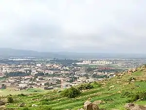
Akele Guzai
Akele Guzai Seb sre (Akeleguzay Eritrea) was a province in the interior of Eritrea until 1996, when the newly independent national government consolidated all provinces into six regions. The province's estimated population was 460,000 in 1990 and had an area of 8400 km2, is mostly consisted of Tigrinya and Saho ethnic groups. Akele Guzai is home to more than three-fourths of the total Saho-speaking population in Eritrea. The Tigrinya people of Akele Guzai are mostly followers of the Eritrean Orthodox Tewahedo Church, while the Saho are predominantly Sunni Muslims. The province of Akele Guzai is now mostly part of the Northern Red Sea Region and the Southern Region.

History
Akele Guzai is one of the most ancient regions of Eritrea. It has an inscriptional record going back to at least the 9th century BC, the earliest example of the In the Ge'ez script. The province was part of Dʿmt, which would evolve into the Kingdom of Aksum.[1]
Akele Guzai's name has been connected by some to the Gaze of the Monumentum Adulitanum (which later medieval Greek notes in the margins associate with the Aksumite people[2]).[3] If the note regarding the Gaze is accurate, it would connect the name of Akele Guzai to the Agʿazyān or Agʿazi (Ge'ez speakers) of the Kingdom of Dʿmt in Eritrea and northern Ethiopia. This connection has been rejected by linguists in modern times, however, due to the lack of the middle voiced pharyngeal fricative in the triliteral roots, which is usually preserved in Tigrinya.[4]
Instead, the name may be connected with the Agazian clan conquered by the 4th-century king Ezana of Axum, and the Agʿaze (unvocalized 'GZ, referring either to a person or a group) of the Hawulti at Matara. Along with Agame in Ethiopia, it was a main center of Aksumite culture (second only to Western Tigray, where the capital was located), with a distinct sub-culture that separated the two regions from that of Western Tigray (Shire, Axum, Yeha), Central Eritrea (Serae, Hamasien, and Adulis), and frontier areas in northern Eritrea and Central Ethiopia.[5][6]
In the Middle Ages, parts of southern Akele Guzai were briefly part of the larger province of Bur, Ethiopia, which also included Agame, some northeastern Afar lowlands, and the Buri Peninsula; southern Akele Guzai and Agame were part of "Upper" (La'ilay) Bur, while the lowlands were further distinguished as "Lower" (Tahtay).[7]
References
- Fattovich, Rodolfo, "Akkälä Guzay" in Uhlig, Siegbert, ed. Encyclopaedia Aethiopica: A-C. Wiesbaden: Otto Harrassowitz KG, 2003, p. 169.
- Stuart Munro-Hay, Aksum: An African Civilization of Late Antiquity. Edinburgh: University Press, 1991. Page 187 in "online version" (PDF). (838 KiB)
- L. P. Kirwan, "The Christian Topography and the Kingdom of Axum" in The Geographical Journal. The Royal Geographical Society (with the Institute of British Geographers), 1972. p.173.
- Alfred Felix Landon Beeston, "Review: Excavations at Aksum: An Account of Research at the Ancient Ethiopian Capital Directed in 1972-74", in Bulletin of the School of Oriental and African Studies, University of London. School of Oriental and African Studies, 1992.
- Stuart Munro-Hay, Aksum: An African Civilization of Late Antiquity. Edinburgh: University Press, 1991. "Online version" (PDF). (838 KiB), pp.36-37.
- Rodolfo Fattovich, "Some Data for the study of Cultural History in Ancient Northern Ethiopia" in Nyame Akuma. Newsletter of the Society of Africanist Archaeologists in America, May 1977, pp. 6-18.
- "Bur" in Uhlig, Siegbert, ed. Encyclopaedia Aethiopica: A-C. Wiesbaden: Otto Harrassowitz KG, 2003.
8.^ Hanevik,Kurt."Eritrea amputee statistics by popuation". https://folk.uib.no/mfakh/LM/amputees.html