Ōwhango railway station
Ōwhango was a station on the North Island Main Trunk line,[1] in the Ruapehu District of New Zealand. It served the village of Ōwhango, which lay to the north of the station.[2] It was 5.64 km (3.50 mi) north of Oio and 9.11 km (5.66 mi) south of Kakahi. The Public Works Department transferred the station to NZ Railways on 9 November 1908, though bush had been felled along the railway route in 1904,[3] by March 1905 a station yard was being formed[4] and by August 1905 it was the railhead, with track laid 4 mi (6.4 km) beyond to the south.[5]
Ōwhango railway station | |||||||||||
|---|---|---|---|---|---|---|---|---|---|---|---|
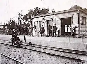
 Ōwhango railway station about 1910 | |||||||||||
| Location | New Zealand | ||||||||||
| Coordinates | 39.006577°S 175.376367°E | ||||||||||
| Elevation | 457 m (1,499 ft) | ||||||||||
| Line(s) | North Island Main Trunk | ||||||||||
| Distance | Wellington 371.89 km (231.08 mi) | ||||||||||
| History | |||||||||||
| Opened | 1905 | ||||||||||
| Closed | 2 June 1985 | ||||||||||
| Electrified | June 1988 | ||||||||||
| Services | |||||||||||
| |||||||||||
By 20 March 1908 there was a 225 ft (69 m) x 20 ft (6.1 m) passenger platform, a 22 ft (6.7 m) x 9 ft (2.7 m) shelter shed, with lobby and store, a tablet office, a loading bank, cattle yards and pens, a 30 ft (9.1 m) x 20 ft (6.1 m) goods shed with verandah, privies, urinals and 4 water tanks of 2,000 imp gal (9.1 m3) each, with water supplied by a hydraulic ram. A 6th class station, cart approach to the platform and fixed signals were added by 10 November 1908 and a sheep yard in 1909.[4] In 1912 the platform was enlarged.[6] In 1964 the timber platform front was renewed, but on 30 January 1965 the station building burnt down. By 21 July 1980 a building, with a brick veneer and a concrete floor, had replaced it.[4]

By 20 March 1908 there was a passing loop for 48 wagons. In 1980 it was extended to an 82 wagon capacity.[4] In 1910 a large timber mill and siding were built.[7] Traffic in 1911 averaged 6 wagon loads a day.[8] from 5 nearby sawmills,[9] which cut matai, rimu and kahikatea.[10]

Passenger traffic had ceased by 1976.[1] On 2 June 1985 Ōwhango closed to goods too,[4] though the crossing loop remains in use.[11]
References
- Scoble, Juliet. "Names & Opening & Closing Dates of Railway Stations in New Zealand 1863 to 2010" (PDF). Rail Heritage Trust of New Zealand.
- "Sheet: WN8". www.mapspast.org.nz. 1928. Retrieved 2020-08-16.
- "MAIN TRUNK LINE. NEW ZEALAND TIMES". paperspast.natlib.govt.nz. 24 Mar 1904. Retrieved 2020-08-14.
- "Stations" (PDF). NZR Rolling Stock Lists. Retrieved 2020-08-10.
- "PUBLIC WORKS STATEMENT". paperspast.natlib.govt.nz. 29 Aug 1905. Retrieved 2020-08-14.
- "TAUMARUNUI. NEW ZEALAND HERALD". paperspast.natlib.govt.nz. 6 Jun 1912. Retrieved 2020-08-14.
- "THE MARCH OF SETTLEMENT. AUCKLAND STAR". paperspast.natlib.govt.nz. 1 Dec 1910. Retrieved 2020-08-14.
- "ON THE MAIN TRUNK LINE. NEW ZEALAND HERALD". paperspast.natlib.govt.nz. 24 Aug 1911. Retrieved 2020-08-14.
- "ALONG THE MAIN TRUNK. NEW ZEALAND HERALD". paperspast.natlib.govt.nz. 27 Nov 1911. Retrieved 2020-08-14.
- "ALONG THE MAIN TRUNK. NEW ZEALAND HERALD". paperspast.natlib.govt.nz. 9 May 1912. Retrieved 2020-08-14.
- "2264 SH 4 Owhango". Google Maps. May 2019. Retrieved 2020-08-16.